Home > Africa > Zimbabwe > Rhodesia
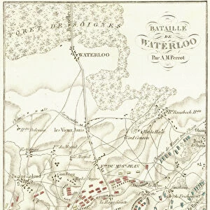
Map Of East Africa At Beginning Of First World War. From The Great World War A History Volume Iii, Published 1916

![]()
Wall Art and Photo Gifts from Design Pics
Map Of East Africa At Beginning Of First World War. From The Great World War A History Volume Iii, Published 1916
Design Pics offers Distinctively Different Imagery representing over 1,500 contributors
Media ID 18190093
© Ken Welsh / Design Pics
Africa Belgian Congo East First German Great Northern Portuguese World Southern Rhodesia
FEATURES IN THESE COLLECTIONS
> Africa
> Related Images
> Africa
> Zimbabwe
> Rhodesia
> Europe
> Belgium
> Related Images
> Europe
> Portugal
> Related Images
EDITORS COMMENTS
This print showcases a historical map of East Africa at the onset of the First World War. Published in 1916 as part of "The Great World War: A History Volume III" this illustration by Ken Welsh offers a fascinating glimpse into the geopolitical landscape of that time. The map depicts various regions and territories, highlighting both German-controlled areas and those under British, Belgian, and Portuguese influence. It provides an invaluable visual representation of Northern and Southern Rhodesia (now Zambia and Zimbabwe), showcasing their strategic importance during this tumultuous period. As we delve into this snapshot from history, it becomes evident how colonial powers vied for dominance over African territories during the war. The intricate details on the map reveal borders, rivers, cities, mountain ranges, and other geographical features that played significant roles in shaping military strategies. Ken Welsh's meticulous craftsmanship is evident through his attention to detail in capturing every contour accurately. This print serves as a reminder not only of the vastness and diversity of East Africa but also its pivotal role within global conflicts. Whether you are a history enthusiast or simply appreciate cartographic artistry, this remarkable piece transports you back to an era when nations clashed over power dynamics on African soil.
MADE IN AUSTRALIA
Safe Shipping with 30 Day Money Back Guarantee
FREE PERSONALISATION*
We are proud to offer a range of customisation features including Personalised Captions, Color Filters and Picture Zoom Tools
SECURE PAYMENTS
We happily accept a wide range of payment options so you can pay for the things you need in the way that is most convenient for you
* Options may vary by product and licensing agreement. Zoomed Pictures can be adjusted in the Cart.