Home > Aerial Photography > France
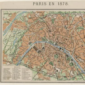
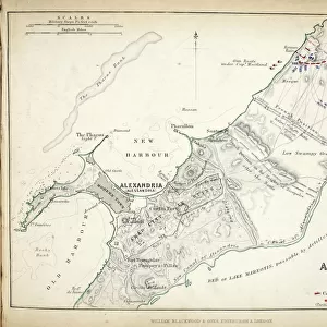
Map of the Battles of Champaubert and Vauchamps, published by William Blackwood and Sons

![]()
Wall Art and Photo Gifts from Fine Art Finder
Map of the Battles of Champaubert and Vauchamps, published by William Blackwood and Sons
746881 Map of the Battles of Champaubert and Vauchamps, published by William Blackwood and Sons, Edinburgh & London, 1848 (hand-coloured engraving) by Johnston, Alexander Keith (1804-71); Private Collection; (add.info.: Battle of Champaubert (February 10, 1814). Battle of Vauchamps (February 14, 1814).
); The Stapleton Collection; Scottish, out of copyright
Media ID 22823160
© The Stapleton Collection / Bridgeman Images
Aerial View Armies Blucher Cartography Mapping Napoleon Positions War Of The Sixth Coalition Prussia Prussian
FEATURES IN THESE COLLECTIONS
> Arts
> Artists
> Related Images
> Europe
> Russia
> Aerial Views
> Europe
> United Kingdom
> England
> London
> Related Images
> Europe
> United Kingdom
> Scotland
> Edinburgh
> Edinburgh
> Europe
> United Kingdom
> Scotland
> Lothian
> Edinburgh
> Fine Art Finder
> Artists
> Alexander Keith Johnston
> Fine Art Finder
> Maps (celestial & Terrestrial)
EDITORS COMMENTS
This hand-colored engraving, titled "Map of the Battles of Champaubert and Vauchamps" takes us back to the tumultuous era of the early 19th century. Published by William Blackwood and Sons in Edinburgh & London in 1848, this historical print offers a detailed depiction of two significant battles from the War of the Sixth Coalition. The first battle depicted is that of Champaubert, which took place on February 10,1814. This clash between Napoleon's French army and Russian forces was a crucial turning point in the campaign. The map showcases strategic positions and provides an aerial view that allows viewers to immerse themselves in the intensity of this historic event. Moving forward on this remarkable piece, we encounter another pivotal engagement: the Battle of Vauchamps on February 14,1814. Here again, Napoleon's troops faced off against Prussian forces led by General Blucher. The map enables us to trace their movements across French territory as they fought for dominance. With its meticulous cartography and intricate detailing, this engraving serves as both a historical record and a work of art. It transports us back to an era defined by military prowess and political upheaval. As we explore each line and contour on this map, we gain insight into these momentous battles that shaped European history. Now part of a private collection within The Stapleton Collection, this exquisite print captures not only our attention but also our imagination as it brings history alive before our
MADE IN AUSTRALIA
Safe Shipping with 30 Day Money Back Guarantee
FREE PERSONALISATION*
We are proud to offer a range of customisation features including Personalised Captions, Color Filters and Picture Zoom Tools
SECURE PAYMENTS
We happily accept a wide range of payment options so you can pay for the things you need in the way that is most convenient for you
* Options may vary by product and licensing agreement. Zoomed Pictures can be adjusted in the Cart.