Home > Arts > Artists > H > Franz Hogenberg
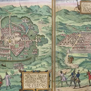
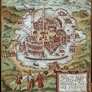
Map of Mexico (Mexico) and Cuzco (Cusco) (Peru) (etching, 1572-1617)
 and Cuzco (Cusco) (Peru) (etching, 1572-1617)")
![]()
Wall Art and Photo Gifts from Fine Art Finder
Map of Mexico (Mexico) and Cuzco (Cusco) (Peru) (etching, 1572-1617)
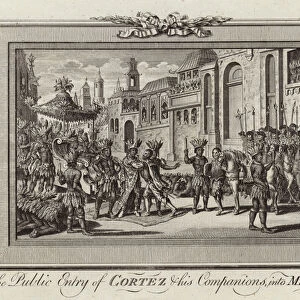
LRI4708619 Map of Mexico (Mexico) and Cuzco (Cusco) (Peru) (etching, 1572-1617) by Hogenberg, Franz (1540-c.1590); Private Collection; (add.info.: Map of Mexico (Mexico) and Cuzco (Cusco) (Peru) - Strong water extracted from Civitates Orbis Terrarum (Atlas of World Cities) by Georg Braun (1541-1622) and Franz Hogenberg (1540-1590), published from 1572 to 1617 - Mexico city (Mexico) and Cusco (Peru) - From " Civitates Orbis Terrarum" G. Braun and F. Hogenberg, 1572-1617); Luisa Ricciarini; Netherlandish, out of copyright
Media ID 22837322
© Luisa Ricciarini / Bridgeman Images
Atlas Book Central America Geographical Map Mexican Mexico Perou Peruvian Exterior View
FEATURES IN THESE COLLECTIONS
> Arts
> Artists
> H
> Franz Hogenberg
> Arts
> Artists
> R
> Arthur Rackham
> Fine Art Finder
> Artists
> Arthur Rackham
> Fine Art Finder
> Artists
> Franz Hogenberg
> Maps and Charts
> World
> North America
> Mexico
> Maps
> North America
> Mexico
> Mexico City
> South America
> Peru
> Cusco
> South America
> Peru
> Maps
EDITORS COMMENTS
This print showcases a remarkable etching titled "Map of Mexico (Mexico) and Cuzco (Cusco) (Peru)" created by the talented artist Franz Hogenberg. The artwork, extracted from the renowned Civitates Orbis Terrarum atlas, offers a glimpse into the geographical beauty of Mexico City and Cusco during the late 16th century. Hogenberg's intricate engraving skillfully captures the essence of these vibrant cities, providing an exterior view that transports viewers back in time. The map not only serves as a visual representation but also acts as a historical document, shedding light on the rich cultural heritage and architectural marvels of both regions. Published between 1572 and 1617 by Georg Braun and Franz Hogenberg themselves, this masterpiece is part of a larger collection known as Civitates Orbis Terrarum - Atlas of World Cities. It stands as a testament to their dedication in documenting various cities across the globe. Luisa Ricciarini has beautifully preserved this invaluable piece through her expert photography skills. Her attention to detail allows us to appreciate every intricacy within Hogenberg's work while highlighting its significance in understanding Mexican and Peruvian history. As we gaze upon this mesmerizing print, we are reminded of how art can transcend time, connecting us with past civilizations and offering insights into our shared human experience.
MADE IN AUSTRALIA
Safe Shipping with 30 Day Money Back Guarantee
FREE PERSONALISATION*
We are proud to offer a range of customisation features including Personalised Captions, Color Filters and Picture Zoom Tools
SECURE PAYMENTS
We happily accept a wide range of payment options so you can pay for the things you need in the way that is most convenient for you
* Options may vary by product and licensing agreement. Zoomed Pictures can be adjusted in the Cart.