Home > Arts > Artists > D > Nicolas de Fer
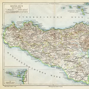
Atlas or collection of geographic maps established on the new observations of gentlemen of the Royal Academy of Sciences. Map of the Mediterranean Sea and Mediterranean countries (spain, france, italy, maghreb)
")
![]()
Wall Art and Photo Gifts from Fine Art Finder
Atlas or collection of geographic maps established on the new observations of gentlemen of the Royal Academy of Sciences. Map of the Mediterranean Sea and Mediterranean countries (spain, france, italy, maghreb)
JEB4874666 Atlas or collection of geographic maps established on the new observations of gentlemen of the Royal Academy of Sciences. Map of the Mediterranean Sea and Mediterranean countries (spain, france, italy, maghreb, turkey...) made by Nicolas de fer (1646-1720). Municipal library of Marseille; (add.info.: Atlas or collection of geographic maps established on the new observations of gentlemen of the Royal Academy of Sciences. Map of the Mediterranean Sea and Mediterranean countries (spain, france, italy, maghreb, turkey...) made by Nicolas de fer (1646-1720). Municipal library of Marseille); © Jean Bernard. All rights reserved 2023
Media ID 38106148
© © Jean Bernard. All rights reserved 2024 / Bridgeman Images
17th Centuries 18e Siecle 18th Century 18th Centuries Africa African African Geographical Map Mediterranean Sea Open Book
FEATURES IN THESE COLLECTIONS
> Arts
> Artists
> D
> Nicolas de Fer
> Asia
> Turkey
> Related Images
> Europe
> France
> Marseilles
> Fine Art Finder
> Artists
> Artist Unknown
> Maps and Charts
> Early Maps
> Maps and Charts
> Italy
EDITORS COMMENTS
This stunning print showcases an Atlas or collection of geographic maps created by Nicolas de Fer in the 17th century. The map focuses on the Mediterranean Sea and surrounding countries such as Spain, France, Italy, Maghreb, and Turkey. These detailed observations were established by gentlemen of the Royal Academy of Sciences, highlighting the precision and dedication put into mapping out these regions.
The intricate details captured in this print offer a glimpse into the past, allowing us to appreciate the historical significance of cartography during this time period. From coastlines to borders, every element is meticulously drawn to provide an accurate representation of the Mediterranean region.
Displayed at the Municipal Library of Marseille, this piece serves as a valuable resource for studying geography and understanding how our world has evolved over centuries. It not only showcases the beauty of mapmaking but also sheds light on the advancements made in scientific exploration during this era.
As we admire this work of art by Jean Bernard, we are reminded of the importance of preserving history through visual representations like these maps. They serve as a reminder that knowledge is power and that through careful observation and documentation, we can gain a deeper understanding of our world.
MADE IN AUSTRALIA
Safe Shipping with 30 Day Money Back Guarantee
FREE PERSONALISATION*
We are proud to offer a range of customisation features including Personalised Captions, Color Filters and Picture Zoom Tools
SECURE PAYMENTS
We happily accept a wide range of payment options so you can pay for the things you need in the way that is most convenient for you
* Options may vary by product and licensing agreement. Zoomed Pictures can be adjusted in the Cart.