Home > Europe > Italy > Emilia-Romagna > Ravenna
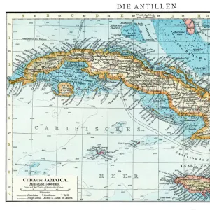
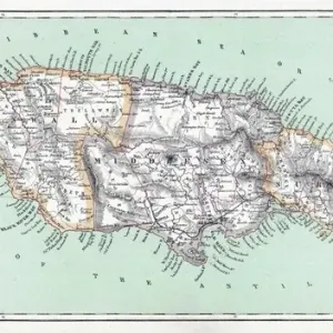
Geography: representation of the Caribbean Sea with the island of Cuba, Jamaica and Hispaniola. Map taken from an Atlas of American Cotes by Pieter Vander AA based on the description of the New World at the time of its discovery by Christopher

![]()
Wall Art and Photo Gifts from Fine Art Finder
Geography: representation of the Caribbean Sea with the island of Cuba, Jamaica and Hispaniola. Map taken from an Atlas of American Cotes by Pieter Vander AA based on the description of the New World at the time of its discovery by Christopher
VEN5031173 Geography: representation of the Caribbean Sea with the island of Cuba, Jamaica and Hispaniola. Map taken from an Atlas of American Cotes by Pieter Vander AA based on the description of the New World at the time of its discovery by Christopher Columbus, 1720. Biblioteca Jose Marti, Havana, Cuba.; (add.info.: Geography: representation of the Caribbean Sea with the island of Cuba, Jamaica and Hispaniola. Map taken from an Atlas of American Cotes by Pieter Vander AA based on the description of the New World at the time of its discovery by Christopher Columbus, 1720. Biblioteca Jose Marti, Havana, Cuba.); Photo © Marco Ravenna
Media ID 38109306
© Photo © Marco Ravenna / Bridgeman Images
18eme Siecle America Continent Amerique Centrale Amerique Continent Amerique Du Nord Caraïbes Caribbean Caribbean Island Carte Geographique Central America Cuba Cuba Cubain Cubaine Cubains Cubaines Cuban Etats Unis Geographical Map Geographie Jamaica Jamaican Stockravenna
FEATURES IN THESE COLLECTIONS
> Europe
> Italy
> Emilia-Romagna
> Ravenna
> Fine Art Finder
> Artists
> Artist Unknown
> Maps and Charts
> Early Maps
> Maps and Charts
> World
> North America
> Cuba
> Cuba Heritage Sites
> Old Havana and its Fortification System
> North America
> Cuba
> Havana
> North America
> Cuba
> Maps
> North America
> Cuba
> Related Images
> North America
> Jamaica
> Maps
> North America
> Jamaica
> Related Images
EDITORS COMMENTS
This stunning print captures a historical representation of the Caribbean Sea, featuring the islands of Cuba, Jamaica, and Hispaniola. The map is taken from an Atlas of American Coasts by Pieter Vander AA, based on the description of the New World at the time of its discovery by Christopher Columbus in 1720.
The intricate details on this map showcase the geography of these iconic Caribbean islands during the 18th century. From the lush landscapes to the intricate coastlines, every aspect is meticulously depicted in this engraving.
As you gaze upon this piece, you can't help but be transported back in time to an era when exploration and discovery shaped our understanding of the world. The vibrant colors and fine lines bring to life a snapshot of history that continues to captivate us today.
Whether you have a personal connection to these islands or simply appreciate their beauty from afar, this print serves as a reminder of the rich heritage and natural wonders that define the Caribbean region. It's a true work of art that celebrates both history and geography in equal measure.
MADE IN AUSTRALIA
Safe Shipping with 30 Day Money Back Guarantee
FREE PERSONALISATION*
We are proud to offer a range of customisation features including Personalised Captions, Color Filters and Picture Zoom Tools
SECURE PAYMENTS
We happily accept a wide range of payment options so you can pay for the things you need in the way that is most convenient for you
* Options may vary by product and licensing agreement. Zoomed Pictures can be adjusted in the Cart.