Home > Africa > Mauritius > Maps
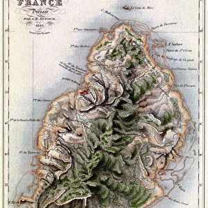
Carte de l'Isle de France levee geometriquement par Mr. l'Abbe de la Caille, de l'Academie Royale des Sciences, en 1753, 1753 (hand coloured engraving)
")
![]()
Wall Art and Photo Gifts from Fine Art Finder
Carte de l'Isle de France levee geometriquement par Mr. l'Abbe de la Caille, de l'Academie Royale des Sciences, en 1753, 1753 (hand coloured engraving)
7339489 Carte de l'Isle de France levee geometriquement par Mr. l'Abbe de la Caille, de l'Academie Royale des Sciences, en 1753, 1753 (hand coloured engraving) by Lacaille, Nicolas-Louis de (18th century); 48x35 cm; National Maritime Museum, London, UK; (add.info.: Creator: Ll'Abbe de la Caille; Lattre
Single sheet. Scale: [ca.1:200 000]. Cartographic Note: Graduated map. Scale in toises. Measured base-lines shown. Additional Places: Mauritius.); © National Maritime Museum, Greenwich, London
Media ID 38176972
© © National Maritime Museum, Greenwich, London / Bridgeman Images
Cartography Islands Isles Mascarene Islands Mauritius
FEATURES IN THESE COLLECTIONS
> Africa
> Mauritius
> Related Images
> Animals
> Mammals
> Cercopithecidae
> Mauritius
> Europe
> United Kingdom
> England
> London
> Boroughs
> Greenwich
> Europe
> United Kingdom
> England
> London
> Museums
> Greenwich Heritage Centre
> Europe
> United Kingdom
> England
> London
> Museums
> National Maritime Museum
> Europe
> United Kingdom
> England
> London
> Museums
> Science Museum
> Europe
> United Kingdom
> England
> London
> Towns
> Greenwich
> Europe
> United Kingdom
> Heritage Sites
> Maritime Greenwich
> Fine Art Finder
> Artists
> British School
EDITORS COMMENTS
This stunning hand-colored engraving, titled "Carte de l'Isle de France levee geometriquement par Mr. l'Abbe de la Caille, de l'Academie Royale des Sciences," offers a glimpse into the meticulous cartographic work of the 18th century. Created by L'Abbe de la Caille in 1753, this map showcases the French island of Mauritius with intricate detail and precision.
The map features a graduated scale in toises and includes measured base-lines for accuracy. It provides a fascinating insight into the geographical knowledge of the time, as well as highlighting the importance of scientific exploration during this period.
The hand-colored elements add depth and vibrancy to the engraving, bringing to life the lush landscapes and coastal features of Mauritius. The careful attention to detail in both design and execution is evident, showcasing the skill and artistry of the engraver.
As you study this historical piece, you can't help but be transported back in time to an era when cartography was at its peak. The combination of artistry and scientific precision makes this print a true masterpiece that captures both the beauty and complexity of mapping an island like Mauritius in the 18th century.
MADE IN AUSTRALIA
Safe Shipping with 30 Day Money Back Guarantee
FREE PERSONALISATION*
We are proud to offer a range of customisation features including Personalised Captions, Color Filters and Picture Zoom Tools
SECURE PAYMENTS
We happily accept a wide range of payment options so you can pay for the things you need in the way that is most convenient for you
* Options may vary by product and licensing agreement. Zoomed Pictures can be adjusted in the Cart.