Home > Europe > United Kingdom > England > Northamptonshire > Northampton
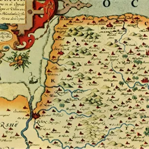
Map of Northampton and adjacent counties, from Atlas of England and Wales

![]()
Wall Art and Photo Gifts from Fine Art Finder
Map of Northampton and adjacent counties, from Atlas of England and Wales
BAL16021 Map of Northampton and adjacent counties, from Atlas of England and Wales, 1576 (copper plate engraving) by Saxton, Christopher (c.1542-c.1610); Map House, London, UK; English, out of copyright
Media ID 12733788
© www.bridgemanimages.com
Cartography County Mapping Northamptonshire
FEATURES IN THESE COLLECTIONS
> Arts
> Artists
> S
> Christopher Saxton
> Europe
> United Kingdom
> England
> London
> Related Images
> Europe
> United Kingdom
> England
> Maps
> Europe
> United Kingdom
> England
> Northamptonshire
> Northampton
> Europe
> United Kingdom
> Maps
> Europe
> United Kingdom
> Wales
> Maps
> Fine Art Finder
> Artists
> Christopher Saxton
> Fine Art Finder
> Maps (celestial & Terrestrial)
> Maps and Charts
> Wales
EDITORS COMMENTS
This print showcases a historical gem, the "Map of Northampton and adjacent counties" from the renowned Atlas of England and Wales. Created in 1576 by Christopher Saxton, a skilled cartographer of his time, this copper plate engraving offers an intriguing glimpse into the past. The map depicts Northamptonshire and its neighboring counties with remarkable detail and precision. Every contour, river, road, and settlement is meticulously laid out on this intricate piece of art. It serves as a testament to Saxton's mastery in capturing geographical information during an era when technology was limited. Displayed against a backdrop of rich colors and delicate lines, this vintage map transports us back to Elizabethan England. It evokes curiosity about how these lands appeared centuries ago – before modern development transformed their landscapes. Preserved within the Map House in London, UK, this print holds immense historical significance. Its availability for public viewing allows enthusiasts to immerse themselves in the world of English cartography from over four centuries ago. As we gaze upon this extraordinary work by Christopher Saxton through our own lens today, we are reminded of the enduring power that maps hold – not only as navigational tools but also as windows into our collective pasts.
MADE IN AUSTRALIA
Safe Shipping with 30 Day Money Back Guarantee
FREE PERSONALISATION*
We are proud to offer a range of customisation features including Personalised Captions, Color Filters and Picture Zoom Tools
SECURE PAYMENTS
We happily accept a wide range of payment options so you can pay for the things you need in the way that is most convenient for you
* Options may vary by product and licensing agreement. Zoomed Pictures can be adjusted in the Cart.