Home > Animals > Insects > Hemiptera > Black Scale
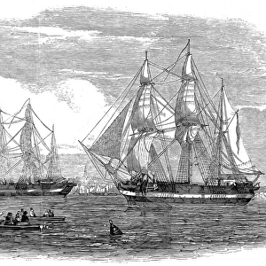
England East Coast from Thames Estuary to the Wash, 1698 (engraving)
")
![]()
Wall Art and Photo Gifts from Fine Art Finder
England East Coast from Thames Estuary to the Wash, 1698 (engraving)
7340590 England East Coast from Thames Estuary to the Wash, 1698 (engraving) by Collins, Greenvile (1643-94); 92x57.5 cm; National Maritime Museum, London, UK; (add.info.: Creator: Grenville Collins
Scale: 1:350,000 (bar). Two copies. Printed chart of the North Sea, Thames Estuary to the Wash. Compass roses and rhumb lines. Shipping scene and elaborate cartouche. Insets: The river of Thames from London to the Buoy of the Nours sold by Richd Mount at the Postern on Great Tower Hill 1:120,000 (bar) Inscribed: 'To the right Worpll the Master and Wardens of the Trinity House of Deptford Stroud this mapp is most humbly dedicatd and presented by Capt Gr. Collins'.); © National Maritime Museum, Greenwich, London
Media ID 38177614
© © National Maritime Museum, Greenwich, London / Bridgeman Images
Cartography Coast Line Estuary Riverthames Thames
FEATURES IN THESE COLLECTIONS
> Animals
> Insects
> Hemiptera
> Black Scale
> Animals
> Insects
> Hemiptera
> Rose Scale
> Europe
> Republic of Ireland
> Maps
> Europe
> United Kingdom
> England
> London
> Boroughs
> Greenwich
> Europe
> United Kingdom
> England
> London
> Museums
> British Museum
> Europe
> United Kingdom
> England
> London
> Museums
> Greenwich Heritage Centre
> Europe
> United Kingdom
> England
> London
> Museums
> National Maritime Museum
> Europe
> United Kingdom
> England
> London
> River Thames
> Europe
> United Kingdom
> England
> London
> Sights
> British Museum
> Fine Art Finder
> Artists
> Claes Jansz Visscher
> Fine Art Finder
> Artists
> Greenvile Collins
EDITORS COMMENTS
This stunning engraving captures the England East Coast from the Thames Estuary to the Wash in 1698, offering a glimpse into the maritime history of this region. Created by Grenville Collins, this detailed map showcases the intricate coastline with compass roses and rhumb lines, providing valuable navigation information for sailors of that era.
The print features a shipping scene and an elaborate cartouche, adding to its historical charm. Insets show the river Thames from London to the Buoy of Nours, highlighting key landmarks along this important waterway.
Inscribed as a dedication to the Master and Wardens of the Trinity House of Deptford Stroud by Capt. Gr. Collins, this map serves as both a practical tool for seafarers and a work of art in its own right.
With its black-and-white aesthetic and meticulous attention to detail, this engraving transports viewers back to a time when England's coastlines were bustling with activity. It is not just a map but a window into the past, showcasing the rich maritime heritage that has shaped this region over centuries.
Displayed at the National Maritime Museum in Greenwich, London, this print is not just an artifact but a testament to England's enduring connection to its coastal waters.
MADE IN AUSTRALIA
Safe Shipping with 30 Day Money Back Guarantee
FREE PERSONALISATION*
We are proud to offer a range of customisation features including Personalised Captions, Color Filters and Picture Zoom Tools
SECURE PAYMENTS
We happily accept a wide range of payment options so you can pay for the things you need in the way that is most convenient for you
* Options may vary by product and licensing agreement. Zoomed Pictures can be adjusted in the Cart.