Home > Maps and Charts > World
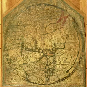
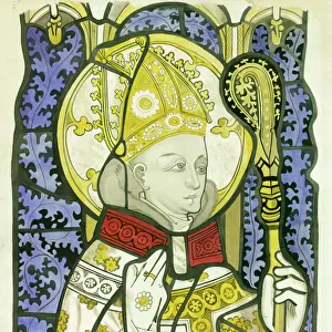
Hereford mappa mundi (world map)
")
Wall Art and Photo Gifts from Fine Art Finder
Hereford mappa mundi (world map)
3849688 Hereford mappa mundi (world map) by Richard of Haldingham (Richard de Bello) (fl.c.1260-1305); 158x133 cm; (add.info.: Hereford mappa mundi (world map).
Copy of original circa 1290 - Largest Medieval map known to exist.); Photo © Derek Bayes. All rights reserved 2022
Media ID 23621144
© Derek Bayes. All rights reserved 2022 / Bridgeman Images
13 13th Xiii Xiiith Century 13 Century 13th Century C13th Cartography Mappa Mundi Place Places Thirteenth Thirteenth Century Vellum World Map Xiii Century Xiiith Century
FEATURES IN THESE COLLECTIONS
> Arts
> Art Movements
> Medieval Art
> Arts
> Artists
> Related Images
> Fine Art Finder
> Artists
> English School
> Fine Art Finder
> Artists
> Richard of Haldingham (fl.c.1260-1305)
> Maps and Charts
> Related Images
> Maps and Charts
> World
EDITORS COMMENTS
This print showcases the Hereford mappa mundi, a remarkable world map created by Richard of Haldingham (Richard de Bello) during the 13th century. Measuring an impressive 158x133 cm, this is the largest surviving medieval map in existence. The intricate details and exquisite craftsmanship on vellum transport viewers back to a time when cartography was still in its infancy. The Hereford mappa mundi offers a fascinating glimpse into how people perceived the world during the Middle Ages. It depicts not only geographical features but also historical events, biblical stories, and mythical creatures. This comprehensive representation reflects the interconnectedness of religion, history, and geography in medieval society. As we explore this masterpiece captured by Derek Bayes' lens, we are reminded of our ancestors' thirst for knowledge and their desire to comprehend their place in the vast universe. Every inch of this map tells a story; every line drawn with precision carries centuries of wisdom. The significance of this artifact extends beyond its aesthetic appeal; it serves as a testament to human curiosity and intellectual pursuits throughout history. Its preservation allows us to appreciate both the artistry involved in its creation and gain insights into medieval beliefs about space and time. Derek Bayes has skillfully immortalized this invaluable piece of history through his photography, allowing us all to marvel at its grandeur from afar while contemplating our own place within an ever-evolving world.
MADE IN AUSTRALIA
Safe Shipping with 30 Day Money Back Guarantee
FREE PERSONALISATION*
We are proud to offer a range of customisation features including Personalised Captions, Color Filters and Picture Zoom Tools
SECURE PAYMENTS
We happily accept a wide range of payment options so you can pay for the things you need in the way that is most convenient for you
* Options may vary by product and licensing agreement. Zoomed Pictures can be adjusted in the Cart.