Home > North America > Cuba > Cuba Heritage Sites > Old Havana and its Fortification System
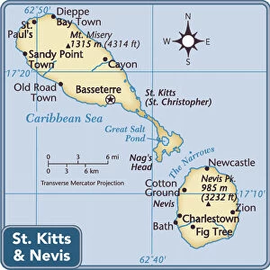
Geography: Map of Saint Kitts and Nevis Island in the West Indies. Map from an Atlas by Bryan Edwards (1743-1800) from 1791. Biblioteca Jose Marti, Havana, Cuba
 from 1791. Biblioteca Jose Marti, Havana, Cuba")
![]()
Wall Art and Photo Gifts from Fine Art Finder
Geography: Map of Saint Kitts and Nevis Island in the West Indies. Map from an Atlas by Bryan Edwards (1743-1800) from 1791. Biblioteca Jose Marti, Havana, Cuba
VEN5031320 Geography: Map of Saint Kitts and Nevis Island in the West Indies. Map from an Atlas by Bryan Edwards (1743-1800) from 1791. Biblioteca Jose Marti, Havana, Cuba; (add.info.: Geography: Map of Saint Kitts and Nevis Island in the West Indies. Map from an Atlas by Bryan Edwards (1743-1800) from 1791. Biblioteca Jose Marti, Havana, Cuba); © Marage Photos
Media ID 38350348
© © Marage Photos / Bridgeman Images
Amerique (continent) Amerique Centrale Amerique Du Nord Caraïbes Caribbean Caribbean Island Carte Geographique Central America Etats Unis Geographie Stockravenna
FEATURES IN THESE COLLECTIONS
> Fine Art Finder
> Artists
> Francois Xavier Fabre
> Maps and Charts
> Early Maps
> North America
> Cuba
> Cuba Heritage Sites
> Old Havana and its Fortification System
> North America
> Cuba
> Havana
> North America
> Cuba
> Maps
> North America
> Cuba
> Related Images
> North America
> Saint Kitts and Nevis
> Maps
> North America
> United States of America
> Maps
> Popular Themes
> North Island
EDITORS COMMENTS
This stunning print captures the intricate and detailed map of Saint Kitts and Nevis Island in the West Indies, created by Bryan Edwards in 1791. The map is a true work of art, showcasing the geography of this beautiful Caribbean island with precision and accuracy.
Bryan Edwards, a renowned cartographer from the 18th century, has expertly depicted every detail of Saint Kitts and Nevis Island on this map. From its lush landscapes to its winding coastlines, viewers can truly appreciate the beauty and complexity of this tropical paradise.
Located in Biblioteca Jose Marti in Havana, Cuba, this historical map is a valuable piece of cartographic history. It provides insight into how people navigated and understood geographical locations centuries ago.
As you gaze upon this image, you can't help but be transported back in time to an era when maps were essential tools for exploration and discovery. The attention to detail and craftsmanship displayed on this map is truly remarkable.
Whether you're a history buff or simply appreciate fine art, this print is sure to captivate your imagination. It serves as a reminder of the rich cultural heritage that exists within our world's diverse landscapes.
MADE IN AUSTRALIA
Safe Shipping with 30 Day Money Back Guarantee
FREE PERSONALISATION*
We are proud to offer a range of customisation features including Personalised Captions, Color Filters and Picture Zoom Tools
SECURE PAYMENTS
We happily accept a wide range of payment options so you can pay for the things you need in the way that is most convenient for you
* Options may vary by product and licensing agreement. Zoomed Pictures can be adjusted in the Cart.