Home > Europe > United Kingdom > England > London > Towns > Willesden
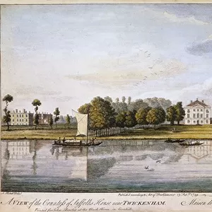
Map of Willesden, London (litho)
")
![]()
Wall Art and Photo Gifts from Fine Art Finder
Map of Willesden, London (litho)
1762021 Map of Willesden, London (litho) by English School; London Metropolitan Archives, City of London; (add.info.: Willesden is an area in North West London which forms part of the London Borough of Brent. It is situated 5 miles (8 km) northwest of Charing Cross. It was historically a parish in the county of Middlesex, that was incorporated as the Municipal Borough of Willesden in 1933 and has formed part of Greater London since 1965.); eLondon Metropolitan Archives; English, out of copyright
Media ID 22262600
© London Metropolitan Archives / Bridgeman Images
Borough Brent Cartographer Cartography Middlesex Willesden
FEATURES IN THESE COLLECTIONS
> Arts
> Artists
> S
> George Shepherd
> Europe
> United Kingdom
> England
> Greater London
> Willesden
> Europe
> United Kingdom
> England
> London
> Boroughs
> Brent
> Europe
> United Kingdom
> England
> London
> Boroughs
> City of London
> Europe
> United Kingdom
> England
> London
> Towns
> Brent
> Europe
> United Kingdom
> England
> London
> Towns
> Willesden
> Europe
> United Kingdom
> England
> Maps
> Europe
> United Kingdom
> England
> Middlesex
> Related Images
> Fine Art Finder
> Artists
> George Shepherd
> Fine Art Finder
> Artists
> School English
> Fine Art Finder
> Maps (celestial & Terrestrial)
> Maps and Charts
> Related Images
EDITORS COMMENTS
This lithograph print showcases a detailed map of Willesden, London. Created by an English School artist, this historical piece is housed in the London Metropolitan Archives and offers a glimpse into the past. Willesden, located in North West London, has been an integral part of the city's landscape for centuries. Situated just 5 miles northwest of Charing Cross, it has witnessed numerous transformations over time. Originally a parish within Middlesex County, Willesden became the Municipal Borough of Willesden in 1933 before eventually becoming part of Greater London in 1965. The map itself provides a wealth of information about this vibrant area. It highlights key landmarks and streets that have shaped its identity throughout history. From bustling city centers to serene residential neighborhoods, every corner is meticulously depicted by the skilled cartographer. As we gaze upon this remarkable artwork from Bridgeman Images' collection at Fine Art Finder, we are transported back to a bygone era when horse-drawn carriages roamed these streets and gas lamps illuminated the night sky. This lithograph serves as both a testament to our ever-evolving urban landscapes and a tribute to those who have called Willesden home throughout generations. It reminds us that beneath the layers of progress lies an enduring sense of community and heritage that continues to shape our modern world today.
MADE IN AUSTRALIA
Safe Shipping with 30 Day Money Back Guarantee
FREE PERSONALISATION*
We are proud to offer a range of customisation features including Personalised Captions, Color Filters and Picture Zoom Tools
SECURE PAYMENTS
We happily accept a wide range of payment options so you can pay for the things you need in the way that is most convenient for you
* Options may vary by product and licensing agreement. Zoomed Pictures can be adjusted in the Cart.