Home > Europe > United Kingdom > England > London > Museums > National Maritime Museum
Pas-caert van de Canael, tusschen Engelandt en Vranckryck, van Pleymuyen tot an de Sorlinges, als mede van Portbimel tot aen Heyssant, 1682 (engraving)
")
![]()
Wall Art and Photo Gifts from Fine Art Finder
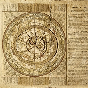
Pas-caert van de Canael, tusschen Engelandt en Vranckryck, van Pleymuyen tot an de Sorlinges, als mede van Portbimel tot aen Heyssant, 1682 (engraving)
7340065 Pas-caert van de Canael, tusschen Engelandt en Vranckryck, van Pleymuyen tot an de Sorlinges, als mede van Portbimel tot aen Heyssant, 1682 (engraving) by Keulen, Johannes van (1654-1715); 50x56.5 cm; National Maritime Museum, London, UK; (add.info.: Creator: Johannes van Keulen
Scale: ca. 1:600 000. The borders are graduated for latitude, the bar scales are in Dutch miles, Spanish miles and English and French miles (actually leagues). It also shows the western approaches, English Channel, Scilly and Ouessant. The cartouche is decorated with a globe, chart and surveying instruments. It's bound in van Keulen's 'Great and Newly Enlarged Sea Atlas' or Waterworld, 1682.); © National Maritime Museum, Greenwich, London
Media ID 38372198
© © National Maritime Museum, Greenwich, London / Bridgeman Images
British Channel English Channel
FEATURES IN THESE COLLECTIONS
> Arts
> Artists
> K
> Johannes van Keulen
> Europe
> Netherlands
> Maps
> Europe
> Republic of Ireland
> Maps
> Europe
> United Kingdom
> England
> London
> Boroughs
> Greenwich
> Europe
> United Kingdom
> England
> London
> Museums
> British Museum
> Europe
> United Kingdom
> England
> London
> Museums
> Greenwich Heritage Centre
> Europe
> United Kingdom
> England
> London
> Museums
> National Maritime Museum
> Europe
> United Kingdom
> England
> London
> Sights
> British Museum
> Fine Art Finder
> Artists
> Hendrick Doncker
> Fine Art Finder
> Artists
> Johannes van Keulen
EDITORS COMMENTS
This stunning engraving from 1682, titled "Pas-caert van de Canael, tusschen Engelandt en Vranckryck," offers a glimpse into the intricate world of cartography in the 17th century. Created by Johannes van Keulen, this detailed map spans from England to France, encompassing landmarks such as Pleymuyen and Portbimel. The scale of approximately 1:600,000 allows for precise navigation through the English Channel and beyond.
The borders of the map are carefully graduated for latitude, while bar scales provide measurements in Dutch miles, Spanish miles, and English and French leagues. The decorative cartouche features a globe surrounded by charting tools, emphasizing the artistry involved in creating such maps during this era.
Bound within van Keulen's 'Great and Newly Enlarged Sea Atlas,' this engraving serves as both a practical navigational tool and a work of art. It captures the maritime heritage of Europe with its depiction of key locations like Scilly and Ouessant.
As you gaze upon this historical print, you can't help but appreciate the dedication to detail that went into its creation. It stands as a testament to the skill and craftsmanship of early cartographers like Johannes van Keulen.
MADE IN AUSTRALIA
Safe Shipping with 30 Day Money Back Guarantee
FREE PERSONALISATION*
We are proud to offer a range of customisation features including Personalised Captions, Color Filters and Picture Zoom Tools
SECURE PAYMENTS
We happily accept a wide range of payment options so you can pay for the things you need in the way that is most convenient for you
* Options may vary by product and licensing agreement. Zoomed Pictures can be adjusted in the Cart.