Home > North America > Cuba > Cuba Heritage Sites > Old Havana and its Fortification System
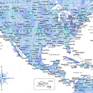
Geography: map of the island of Cuba with detailed map of the city of Havana. View of the entire Gulf of Mexico. Map from an Atlas of 1763. Biblioteca Jose Marti, Havana, Cuba

![]()
Wall Art and Photo Gifts from Fine Art Finder
Geography: map of the island of Cuba with detailed map of the city of Havana. View of the entire Gulf of Mexico. Map from an Atlas of 1763. Biblioteca Jose Marti, Havana, Cuba
VEN5031239 Geography: map of the island of Cuba with detailed map of the city of Havana. View of the entire Gulf of Mexico. Map from an Atlas of 1763. Biblioteca Jose Marti, Havana, Cuba; (add.info.: Geography: map of the island of Cuba with detailed map of the city of Havana. View of the entire Gulf of Mexico. Map from an Atlas of 1763. Biblioteca Jose Marti, Havana, Cuba); © Marage Photos
Media ID 38274512
© © Marage Photos / Bridgeman Images
18eme Siecle Amerique (continent) Amerique Centrale Amerique Du Nord Carte Geographique Central America Cuba Cuba Cubain Cubaine Cubains Cubaines Cuban Etats Unis Geographical Map Geographie Mexican Mexicans Mexico Mexican Mexique Stockravenna
FEATURES IN THESE COLLECTIONS
> Arts
> Photorealistic artworks
> Detailed art pieces
> Masterful detailing in art
> Fine Art Finder
> Artists
> Marcantonio Bassetti
> Maps and Charts
> Early Maps
> North America
> Cuba
> Cuba Heritage Sites
> Old Havana and its Fortification System
> North America
> Cuba
> Havana
> North America
> Cuba
> Maps
> North America
> Cuba
> Related Images
> North America
> Mexico
> Maps
> North America
> Mexico
> Mexico City
> North America
> Mexico
> Related Images
EDITORS COMMENTS
This stunning print captures a piece of history with a detailed map of the island of Cuba and the city of Havana from an Atlas dating back to 1763. The intricate details on the map showcase the geography of Cuba, including its coastline along the Gulf of Mexico.
The map is housed in the Biblioteca Jose Marti in Havana, Cuba, adding to its historical significance. This 18th-century piece provides a glimpse into the past, offering valuable insights into how this region was perceived centuries ago.
As you study this map, you can't help but be transported back in time to when cartography was both an art form and a science. The precision and craftsmanship that went into creating such maps are truly remarkable.
Whether you have a personal connection to Cuba or simply appreciate historical artifacts, this print is sure to captivate your imagination. It serves as a reminder of how much our world has evolved over time while also highlighting the enduring beauty and complexity of geography.
MADE IN AUSTRALIA
Safe Shipping with 30 Day Money Back Guarantee
FREE PERSONALISATION*
We are proud to offer a range of customisation features including Personalised Captions, Color Filters and Picture Zoom Tools
SECURE PAYMENTS
We happily accept a wide range of payment options so you can pay for the things you need in the way that is most convenient for you
* Options may vary by product and licensing agreement. Zoomed Pictures can be adjusted in the Cart.