Home > Animals > Birds > Passerines > Crows And Jays > American Crow
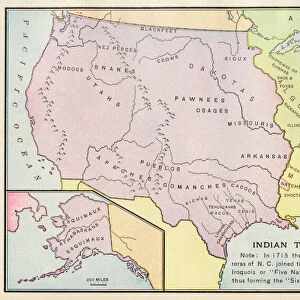
Geographic map of the distribution of Indian tribes (Iroquois, Algonquin, Modoc, Nez Perce, Blackfeet, Crow, Sioux, Ojibwa, Pawnee (or Paneassa, Pari, Pariki), Osage, Kiowa, Caddo, Choctaw, Chickasaw, Seminokee, Shawnee, Powhatan, Catawba
, Osage, Kiowa, Caddo, Choctaw, Chickasaw, Seminokee, Shawnee, Powhatan, Catawba")
![]()
Wall Art and Photo Gifts from Fine Art Finder
Geographic map of the distribution of Indian tribes (Iroquois, Algonquin, Modoc, Nez Perce, Blackfeet, Crow, Sioux, Ojibwa, Pawnee (or Paneassa, Pari, Pariki), Osage, Kiowa, Caddo, Choctaw, Chickasaw, Seminokee, Shawnee, Powhatan, Catawba
NWI4893916 Geographic map of the distribution of Indian tribes (Iroquois, Algonquin, Modoc, Nez Perce, Blackfeet, Crow, Sioux, Ojibwa, Pawnee (or Paneassa, Pari, Pariki), Osage, Kiowa, Caddo, Choctaw, Chickasaw, Seminokee, Shawnee, Powhatan, Catawba, Mobiliary, Apache, Comanche, Pueblo) on North American territory in 1771. Lithography, 19th century.; (add.info.: Geographic map of the distribution of Indian tribes (Iroquois, Algonquin, Modoc, Nez Perce, Blackfeet, Crow, Sioux, Ojibwa, Pawnee (or Paneassa, Pari, Pariki), Osage, Kiowa, Caddo, Choctaw, Chickasaw, Seminokee, Shawnee, Powhatan, Catawba, Mobiliary, Apache, Comanche, Pueblo) on North American territory in 1771. Lithography, 19th century.); Photo © North Wind Pictures
Media ID 38422524
© © North Wind Pictures / Bridgeman Images
American Indian Geographical Map
FEATURES IN THESE COLLECTIONS
> Animals
> Birds
> Passerines
> Crows And Jays
> American Crow
> Animals
> Birds
> Passerines
> Crows And Jays
> Related Images
> Fine Art Finder
> Artists
> Pasquier (workshop of) Grenier
> Maps and Charts
> Early Maps
> North America
> United States of America
> Maps
EDITORS COMMENTS
This stunning lithograph from the 19th century showcases a detailed Geographic map of the distribution of Indian tribes on North American territory in 1771. The map highlights the locations of various tribes such as Iroquois, Algonquin, Modoc, Nez Perce, Blackfeet, Crow, Sioux, Ojibwa, Pawnee, Osage, Kiowa, Caddo and many more.
Each tribe is represented with intricate detail and precision on this historical map. From the East Coast to the Great Plains and beyond, this map provides a glimpse into the rich cultural tapestry of Native American tribes that once inhabited these lands.
The vibrant colors used in this lithograph bring to life the diverse range of indigenous communities that existed across North America during this time period. It serves as a reminder of the deep connection between these tribes and their ancestral homelands.
As we study this map closely, we can appreciate the vastness of tribal territories and how they intersected with one another. It offers a valuable insight into the complex social structures and geographical boundaries that shaped Native American societies centuries ago.
This Geographic map is not just a visual representation but also a testament to the resilience and heritage of these indigenous peoples who continue to preserve their traditions despite centuries of adversity.
MADE IN AUSTRALIA
Safe Shipping with 30 Day Money Back Guarantee
FREE PERSONALISATION*
We are proud to offer a range of customisation features including Personalised Captions, Color Filters and Picture Zoom Tools
SECURE PAYMENTS
We happily accept a wide range of payment options so you can pay for the things you need in the way that is most convenient for you
* Options may vary by product and licensing agreement. Zoomed Pictures can be adjusted in the Cart.