Home > Europe > United Kingdom > England > Lancashire > Ribble
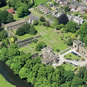
Map of the Battle of Preston of 1715, 1818 (hand-coloured engraving)
")
![]()
Wall Art and Photo Gifts from Fine Art Finder
Map of the Battle of Preston of 1715, 1818 (hand-coloured engraving)
1113181 Map of the Battle of Preston of 1715, 1818 (hand-coloured engraving) by English School, (19th century); 23x29 cm; Harris Museum and Art Gallery, Preston, Lancashire, UK; (add.info.: The Battle of Preston (9-14 November 1715), also referred to as the Preston Fight, was fought during the Jacobite Rising of 1715.
Rebellion suppressed by General Wills. A Map and plan of the Town of Preston with the batteries and barricades of the rebels and the attacks of the Kings forces.
Engraved by Charles St Clare in 1818.); eHarris Museum and Art Gallery; English, out of copyright
Media ID 22630156
© Harris Museum and Art Gallery / Bridgeman Images
Aerial Barricade Barricades Batteries Battery Cartographic Cartography Encampment Event Events Forces Jacobite Jacobites Lancashire Layout Militia Preston Rebel Rebellion Rebels Record Rising Stewart Strategic Strategy Stuart Supporter Supporters Suppressed Wills Ribble
FEATURES IN THESE COLLECTIONS
> Aerial Photography
> Related Images
> Arts
> Artists
> Peter Paul Rubens
> Arts
> Artists
> R
> Peter Paul Rubens
> Arts
> Landscape paintings
> Waterfall and river artworks
> River artworks
> Europe
> United Kingdom
> England
> Lancashire
> Preston
> Europe
> United Kingdom
> England
> Lancashire
> Ribble
> Europe
> United Kingdom
> Maps
> Fine Art Finder
> Artists
> English School
> Fine Art Finder
> Artists
> Peter Paul Rubens
> Fine Art Finder
> War & Military Scenes Pre-20th Century
EDITORS COMMENTS
This hand-coloured engraving from the 19th century depicts a map of the Battle of Preston in 1715, which took place during the Jacobite Rising. The rebellion was ultimately suppressed by General Wills, and this detailed map provides a strategic view of the town's layout, including the batteries and barricades set up by the rebels as well as the attacks launched by King's forces. Engraved by Charles St Clare in 1818, this print offers a fascinating glimpse into an important military event in British history. It showcases not only the positioning and movements of both sides but also highlights key features such as the river Ribble that played a significant role in shaping battle strategies. The aerial perspective allows viewers to appreciate how each force strategically positioned themselves within Preston. The encampments, barricades, and batteries are meticulously depicted on this cartographic masterpiece. This visual record serves as an invaluable resource for historians studying warfare tactics during this period. As you examine this artwork closely, you can almost feel yourself transported back to that momentous time when supporters of Stuart dynasty clashed with British forces. The attention to detail is remarkable; every street corner and building is accurately represented. Displayed at Harris Museum and Art Gallery in Preston, Lancashire, UK, this print stands as a testament to both artistic skill and historical significance. It captures not only a pivotal battle but also reflects upon broader themes such as rebellion, loyalty, and power struggles that shaped Britain's past.
MADE IN AUSTRALIA
Safe Shipping with 30 Day Money Back Guarantee
FREE PERSONALISATION*
We are proud to offer a range of customisation features including Personalised Captions, Color Filters and Picture Zoom Tools
SECURE PAYMENTS
We happily accept a wide range of payment options so you can pay for the things you need in the way that is most convenient for you
* Options may vary by product and licensing agreement. Zoomed Pictures can be adjusted in the Cart.