Home > Europe > Belgium > Maps
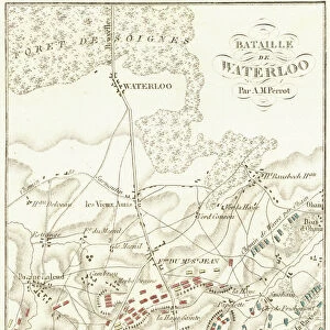
Map of the Flanders Front, World War 1

![]()
Wall Art and Photo Gifts from Fine Art Finder
Map of the Flanders Front, World War 1
3788101 Map of the Flanders Front, World War 1; (add.info.: Map of the front lines in Flanders, Belgium, during World War 1, July and August 1917.
The Year 1917 Illustrated. London: Headley Bros, 1917.); Lebrecht History
Media ID 33390006
© Lebrecht History / Bridgeman Images
Cartography Countries Tint Tinted
FEATURES IN THESE COLLECTIONS
> Europe
> Belgium
> Related Images
> Fine Art Finder
> Artists
> School Russian
> Maps and Charts
> Early Maps
> Maps and Charts
> Related Images
> Maps and Charts
> World
EDITORS COMMENTS
This print showcases a historically significant artifact - the "Map of the Flanders Front, World War 1". With its intricate details and vibrant colors, this map offers a glimpse into the tumultuous events that unfolded in Flanders, Belgium during July and August 1917. The map's cartography skillfully outlines the front lines of one of the most pivotal battlegrounds of World War 1. It serves as a visual testament to the immense scale and complexity of military operations during this time. The tinted hues add depth to the illustration, evoking a sense of urgency and intensity that characterized this era. Dating back to early 20th century, this piece is not only an invaluable historical document but also a remarkable work of art. Its meticulous drawings depict various countries involved in the conflict, highlighting their strategic positions on the world stage. Moreover, it provides insights into how industrialization played a crucial role in shaping warfare tactics during World War 1. As we delve into this image, we are transported back in time - witnessing firsthand how nations mobilized their resources and industries for war efforts. This map symbolizes both tragedy and resilience; it represents countless lives lost while also showcasing human ingenuity amidst chaos. Bridgeman Images has masterfully captured every detail with precision and clarity through Fine Art Finder. By preserving such artifacts digitally, they ensure that future generations can continue to study and appreciate these important historical moments. In conclusion, this print immortalizes an extraordinary piece from Lebrecht History's collection - offering us an opportunity to reflect upon our shared past while honoring those who endured unimaginable hardships during World War 1.
MADE IN AUSTRALIA
Safe Shipping with 30 Day Money Back Guarantee
FREE PERSONALISATION*
We are proud to offer a range of customisation features including Personalised Captions, Color Filters and Picture Zoom Tools
SECURE PAYMENTS
We happily accept a wide range of payment options so you can pay for the things you need in the way that is most convenient for you
* Options may vary by product and licensing agreement. Zoomed Pictures can be adjusted in the Cart.