Home > Arts > Artists > H > William Hodges
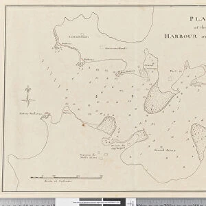
Page 37a A Sketch of Block Island, latitude of the South Head 41: 9 N

![]()
Wall Art and Photo Gifts from Fine Art Finder
Page 37a A Sketch of Block Island, latitude of the South Head 41: 9 N
5670302 Page 37a A Sketch of Block Island, latitude of the South Head 41: 9 N, 1768-75 (pen & ink) by Hodges, William (1744-97); Mitchell Library, State Library of New South Wales; (add.info.: Original Sketches, Drawings, Maps etc Collected by Admiral Isaac Smith / drawings and watercolours, mainly of Captain Cooks Second Voyage (1772-1775) by William Hodges, Henry Roberts etc
Dimensions: Album measures 49 x 70 cm); Mitchell Library, State Library of New South Wales; English, out of copyright
Media ID 23272666
© Mitchell Library, State Library of New South Wales / Bridgeman Images
Cartographic Cartography Features Geographical Hydrographic Label Labelled Lagoon Mapping Numbered Numbers Scale Survey Surveying
FEATURES IN THESE COLLECTIONS
> Arts
> Artists
> H
> William Hodges
> Europe
> United Kingdom
> Wales
> Maps
> Fine Art Finder
> Artists
> William Hodges
> Maps and Charts
> Wales
EDITORS COMMENTS
Page 37a A Sketch of Block Island, latitude of the South Head 41:9 N (1768-75) by William Hodges captures the essence of adventure and exploration during Captain Cook's Second Voyage. This pen and ink drawing, now housed in the Mitchell Library at the State Library of New South Wales, offers a glimpse into the meticulous mapping efforts undertaken by Hodges and his contemporaries. The sketch showcases Block Island's coastline with intricate detail, highlighting landmarks such as George's Ledge. Each feature is carefully labeled and numbered, providing valuable information for future navigators. The scale incorporated within the map allows viewers to comprehend distances accurately. Dating back to the eighteenth century, this cartographic masterpiece exemplifies both artistic skill and scientific precision. It serves as a testament to Hodges' expertise in surveying and hydrography. The lagoon depicted on the sketch adds an enchanting touch to this historical artifact. As we admire this print from Fine Art Finder, we are transported back in time to an era when maritime exploration was at its peak. The coastal beauty captured by Hodges invites us to imagine ourselves sailing alongside Captain Cook on his legendary voyage. This image is not just a mere representation; it encapsulates centuries of geographical knowledge and curiosity about uncharted territories. Let us appreciate this remarkable piece that stands as a tribute to human ingenuity.
MADE IN AUSTRALIA
Safe Shipping with 30 Day Money Back Guarantee
FREE PERSONALISATION*
We are proud to offer a range of customisation features including Personalised Captions, Color Filters and Picture Zoom Tools
SECURE PAYMENTS
We happily accept a wide range of payment options so you can pay for the things you need in the way that is most convenient for you
* Options may vary by product and licensing agreement. Zoomed Pictures can be adjusted in the Cart.