Home > Arts > Artists > J > Thomas Jefferys
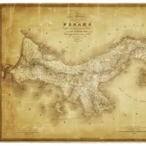
Geography Atlas: representation of the island of Antigua and Barbuda (Antilles). Map taken from "The west indian atlas or general description of west indies"" by Thomas Jefferys, geographer of the Prince of Wales, 1774
. Map taken from 'The west indian atlas or general description of west indies'' by Thomas Jefferys, geographer of the Prince of Wales, 1774")
![]()
Wall Art and Photo Gifts from Fine Art Finder
Geography Atlas: representation of the island of Antigua and Barbuda (Antilles). Map taken from "The west indian atlas or general description of west indies"" by Thomas Jefferys, geographer of the Prince of Wales, 1774
VEN5031159 Geography Atlas: representation of the island of Antigua and Barbuda (Antilles). Map taken from "The west indian atlas or general description of west indies"" by Thomas Jefferys, geographer of the Prince of Wales, 1774. Biblioteca Jose Marti, Havana, Cuba.; (add.info.: Geography Atlas: representation of the island of Antigua and Barbuda (Antilles). Map taken from "The west indian atlas or general description of west indies"" by Thomas Jefferys, geographer of the Prince of Wales, 1774. Biblioteca Jose Marti, Havana, Cuba.); © Marage Photos
Media ID 38164350
© © Marage Photos / Bridgeman Images
18eme Siecle Amerique (continent) Amerique Centrale Amerique Du Nord Caraïbes Caribbean Caribbean Island Carte Geographique Central America Etats Unis Geographical Map Geographie Stockravenna
FEATURES IN THESE COLLECTIONS
> Arts
> Artists
> J
> Thomas Jefferys
> Arts
> Artists
> N
> Thomas North
> Europe
> United Kingdom
> Wales
> Maps
> Europe
> United Kingdom
> Wales
> Related Images
> Maps and Charts
> Early Maps
> Maps and Charts
> Wales
> North America
> Antigua and Barbuda
> Maps
> North America
> Cuba
> Cuba Heritage Sites
> Old Havana and its Fortification System
> North America
> Cuba
> Havana
EDITORS COMMENTS
This stunning print captures a historical representation of the island of Antigua and Barbuda in the Antilles, taken from "The West Indian Atlas or General Description of West Indies" by Thomas Jefferys in 1774. The intricate details on this map showcase the geography of the island during the 18th century, providing a glimpse into its past.
Created by Thomas Jefferys, geographer to the Prince of Wales at that time, this map is a valuable piece of cartographic history. It offers insights into how these Caribbean islands were perceived and understood centuries ago, shedding light on their importance in colonial times.
Displayed in the Biblioteca Jose Marti in Havana, Cuba, this Geography Atlas print is not just a visual representation but also a cultural artifact. It serves as a reminder of the rich heritage and complex history of Antigua and Barbuda within the context of Western Hemisphere exploration and colonization.
The detailed engraving showcases key geographical features such as coastlines, rivers, and settlements on these Caribbean islands. It invites viewers to delve into the past and appreciate how our understanding of geography has evolved over time.
Overall, this print is not just an image but a window into another era – offering us a unique perspective on Antigua and Barbuda's place in history.
MADE IN AUSTRALIA
Safe Shipping with 30 Day Money Back Guarantee
FREE PERSONALISATION*
We are proud to offer a range of customisation features including Personalised Captions, Color Filters and Picture Zoom Tools
SECURE PAYMENTS
We happily accept a wide range of payment options so you can pay for the things you need in the way that is most convenient for you
* Options may vary by product and licensing agreement. Zoomed Pictures can be adjusted in the Cart.