Fine Art Print > Africa > Ethiopia (Abyssinia) > Maps
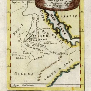
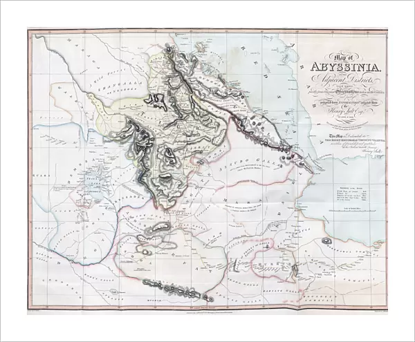
Fine Art Print : Map of Abyssinia and the Adjacent Districts. From observations taken by British traveller and artist Henry Salt in 1809 and 1810. Drawn by J. Outhett and engraved by A. Macpherson. Published 1814. Used in Henry Salts book A voyage to Abyssinia, and Travels into the Interior of that Country


![]()
Fine Art Prints from Design Pics
Map of Abyssinia and the Adjacent Districts. From observations taken by British traveller and artist Henry Salt in 1809 and 1810. Drawn by J. Outhett and engraved by A. Macpherson. Published 1814. Used in Henry Salts book A voyage to Abyssinia, and Travels into the Interior of that Country
Design Pics offers Distinctively Different Imagery representing over 1,500 contributors
Media ID 24905016
© Ken Welsh / Design Pics
Abyssinian Book Ethiopia Geographical Geography Interior Traveller Travellers Travels Trip Voyage Henry Salt Macpherson
20"x16" (+3" Border) Fine Art Print
Step back in time with this exquisite Fine Art Print of "A Map of Abyssinia and the Adjacent Districts," originally published in 1814. Meticulously drawn by J. Outhett from observations made by the renowned British traveller and artist Henry Salt during his expeditions in 1809 and 1810, this historic map is a testament to the rich cultural and geographical explorations of the past. Engraved by A. Macpherson, this beautiful piece was first featured in Salt's seminal work, "A Voyage to Abyssinia, and Travels into the Interior of that Country." Add this captivating piece to your collection and bring the intriguing history of Abyssinia into your home or office.
20x16 image printed on 26x22 Fine Art Rag Paper with 3" (76mm) white border. Our Fine Art Prints are printed on 300gsm 100% acid free, PH neutral paper with archival properties. This printing method is used by museums and art collections to exhibit photographs and art reproductions.
Our fine art prints are high-quality prints made using a paper called Photo Rag. This 100% cotton rag fibre paper is known for its exceptional image sharpness, rich colors, and high level of detail, making it a popular choice for professional photographers and artists. Photo rag paper is our clear recommendation for a fine art paper print. If you can afford to spend more on a higher quality paper, then Photo Rag is our clear recommendation for a fine art paper print.
Estimated Image Size (if not cropped) is 50.8cm x 40.6cm (20" x 16")
Estimated Product Size is 66cm x 55.9cm (26" x 22")
These are individually made so all sizes are approximate
Artwork printed orientated as per the preview above, with landscape (horizontal) orientation to match the source image.
FEATURES IN THESE COLLECTIONS
> Africa
> Ethiopia (Abyssinia)
> Maps
> Africa
> Ethiopia (Abyssinia)
> Related Images
> Africa
> Ethiopia
> Related Images
> Maps and Charts
> British Empire Maps
> Maps and Charts
> Early Maps
> Maps and Charts
> Related Images
EDITORS COMMENTS
This print showcases a historical map titled "Map of Abyssinia and the Adjacent Districts" which was created based on the observations made by British traveler and artist Henry Salt during his expeditions in 1809 and 1810. The intricate details of this illustration were skillfully drawn by J. Outhett and expertly engraved by A. Macpherson, resulting in a visually stunning representation of the region. Published in 1814, this map played a significant role in Henry Salt's renowned book, "A Voyage to Abyssinia, and Travels into the Interior of that Country". It offers an invaluable glimpse into the geography, history, and travels within Ethiopia during the early 19th century. As we explore this archival piece, we are transported back in time to witness how English explorers ventured into uncharted territories to document their findings. This particular map serves as a testament to Henry Salt's dedication towards understanding Abyssinian culture and its surrounding regions. With its rich historical context and meticulous attention to detail, this print is not only a valuable resource for researchers but also an exquisite addition for any lover of geography or history. Its presence allows us to appreciate both Welsh artist J. Outhett's artistic talent as well as A. Macpherson's engraving expertise. Step into the past with this remarkable image – it encapsulates adventure, discovery, and an era when travel was truly an extraordinary voyage into unknown lands.
MADE IN AUSTRALIA
Safe Shipping with 30 Day Money Back Guarantee
FREE PERSONALISATION*
We are proud to offer a range of customisation features including Personalised Captions, Color Filters and Picture Zoom Tools
SECURE PAYMENTS
We happily accept a wide range of payment options so you can pay for the things you need in the way that is most convenient for you
* Options may vary by product and licensing agreement. Zoomed Pictures can be adjusted in the Cart.