Fine Art Print > Fine Art Storehouse > Map
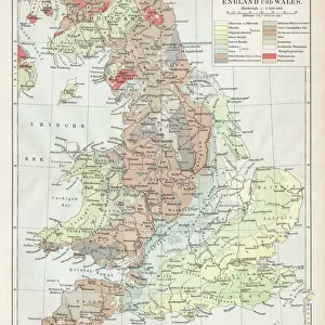
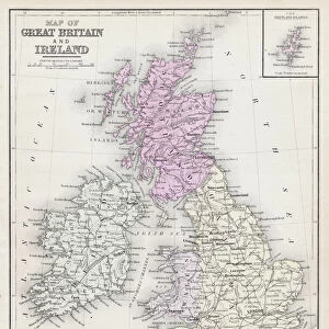
Fine Art Print : Map of Great Britain and Ireland 1883


![]()
Fine Art Prints from Fine Art Storehouse
Map of Great Britain and Ireland 1883
Warrens Common School Geography
Unleash your creativity and transform your space into a visual masterpiece!
THEPALMER
Media ID 13669365
© This content is subject to copyright
20"x16" (+3" Border) Fine Art Print
Discover the rich history and intricate details of Great Britain and Ireland with this stunning Map of Great Britain and Ireland 1883 by THEPALMER from the Media Storehouse Fine Art Prints collection. This exquisite piece, inspired by Warrens Common School Geography, transports you back in time with its vintage charm and meticulous cartography. Bring the beauty of historical geography into your home or office space and add a touch of timeless elegance to your decor. Each print is carefully produced using high-quality materials and techniques to ensure vibrant colors and long-lasting durability. Order now and let this fine art print be a conversation starter and a source of inspiration for generations to come.
20x16 image printed on 26x22 Fine Art Rag Paper with 3" (76mm) white border. Our Fine Art Prints are printed on 300gsm 100% acid free, PH neutral paper with archival properties. This printing method is used by museums and art collections to exhibit photographs and art reproductions.
Our fine art prints are high-quality prints made using a paper called Photo Rag. This 100% cotton rag fibre paper is known for its exceptional image sharpness, rich colors, and high level of detail, making it a popular choice for professional photographers and artists. Photo rag paper is our clear recommendation for a fine art paper print. If you can afford to spend more on a higher quality paper, then Photo Rag is our clear recommendation for a fine art paper print.
Estimated Image Size (if not cropped) is 40.6cm x 49.1cm (16" x 19.3")
Estimated Product Size is 55.9cm x 66cm (22" x 26")
These are individually made so all sizes are approximate
Artwork printed orientated as per the preview above, with portrait (vertical) orientation to match the source image.
FEATURES IN THESE COLLECTIONS
> Fine Art Storehouse
> The Magical World of Illustration
> Palmer Illustrated Collection
> Fine Art Storehouse
> Map
> Historical Maps
EDITORS COMMENTS
This print takes us back in time to the year 1883, when a beautifully detailed "Map of Great Britain and Ireland" was created for Warrens Common School Geography. The image showcases the vertical orientation of this vintage map, allowing us to appreciate its intricate details and historical significance. The map itself is a testament to the artistry and skill of cartographers from that era. Engraved on old paper, it exudes an antique charm that transports us to a bygone era. Every contour line, river, mountain range, and city is meticulously illustrated with precision and care. As we explore this enchanting piece of physical geography, we are reminded of the rich history shared between these lands - England, Scotland, Wales, Northern Ireland - collectively known as Great Britain and neighboring Ireland. It serves as a visual reminder of their interconnectedness despite being separate entities. The craftsmanship captured in this engraved image invites us to reflect on how maps have evolved over time while appreciating their enduring importance in understanding our world's past. This particular artwork by THEPALMER offers not only an aesthetic delight but also sparks curiosity about the geopolitical landscape during the late 19th century. Whether you're an enthusiast for historical artifacts or simply intrigued by cartography's beauty and intricacy, this remarkable print will undoubtedly add character and depth to any space it graces.
MADE IN AUSTRALIA
Safe Shipping with 30 Day Money Back Guarantee
FREE PERSONALISATION*
We are proud to offer a range of customisation features including Personalised Captions, Color Filters and Picture Zoom Tools
SECURE PAYMENTS
We happily accept a wide range of payment options so you can pay for the things you need in the way that is most convenient for you
* Options may vary by product and licensing agreement. Zoomed Pictures can be adjusted in the Cart.