
Fine Art Print > Arts > Artists > W > Charles White
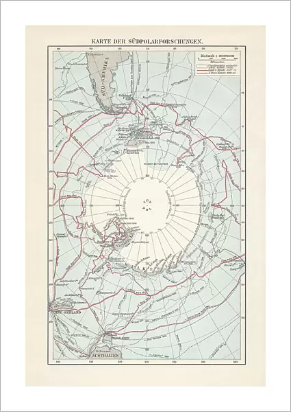
Fine Art Print : Antarctica map with sea routes of various explorers, lithograph, 1897


![]()
Fine Art Prints from Fine Art Storehouse
Antarctica map with sea routes of various explorers, lithograph, 1897
Historical map of the unexplored Antarctica with sea routes of various explorers, 18th - 19th century. Lithograph, published in 1897
Unleash your creativity and transform your space into a visual masterpiece!
ZU_09
Media ID 35843106
18th Century Adventure Antarctica Australia Explorer New Zealand Sea Passage South America South Pole Captain Cook Multi Colored White Color
21"x14" (+3" Border) Fine Art Print
Step back in time with our exquisite Antarctica map print from the Media Storehouse Fine Art collection. This historical lithograph, published in 1897, captures the unexplored beauty of Antarctica as it was once known. Chart the sea routes of brave explorers from the 18th and 19th centuries who dared to venture into the unknown. Add an air of adventure and historical intrigue to your home or office with this stunning, vintage-inspired print. Perfect for history buffs, cartography enthusiasts, or anyone who appreciates the allure of the unknown.
21x14 image printed on 27x20 Fine Art Rag Paper with 3" (76mm) white border. Our Fine Art Prints are printed on 300gsm 100% acid free, PH neutral paper with archival properties. This printing method is used by museums and art collections to exhibit photographs and art reproductions.
Our fine art prints are high-quality prints made using a paper called Photo Rag. This 100% cotton rag fibre paper is known for its exceptional image sharpness, rich colors, and high level of detail, making it a popular choice for professional photographers and artists. Photo rag paper is our clear recommendation for a fine art paper print. If you can afford to spend more on a higher quality paper, then Photo Rag is our clear recommendation for a fine art paper print.
Estimated Image Size (if not cropped) is 35.5cm x 53.3cm (14" x 21")
Estimated Product Size is 50.8cm x 68.6cm (20" x 27")
These are individually made so all sizes are approximate
Artwork printed orientated as per the preview above, with portrait (vertical) orientation to match the source image.
FEATURES IN THESE COLLECTIONS
> Arts
> Artists
> W
> Charles White
> Maps and Charts
> Early Maps
> Maps and Charts
> Related Images
> Oceania
> Australia
> Related Images
> Oceania
> New Zealand
> Maps
> Oceania
> New Zealand
> Related Images
> South America
> Related Images
> Fine Art Storehouse
> Map
> Historical Maps
EDITORS COMMENTS
This stunning lithograph, published in 1897, offers a captivating glimpse into the unexplored territories of Antarctica during the late 18th and 19th centuries. The map, adorned with a crisp white background, vividly depicts the icy continent with intricate detail, its vast expanses of ice and water shimmering in blues and whites. At the heart of the map lies the elusive South Pole, a blank space of uncharted territory, beckoning the brave and the curious. The map is a testament to the spirit of adventure and exploration that defined this era. It marks the sea routes of some of the most renowned explorers of the time, including Captain James Cook and Charles Wilkes. Cook's explorations in the Pacific Ocean brought him close to Antarctica, but he was unable to reach the continent. Wilkes, on the other hand, led the United States Exploring Expedition to Antarctica in the 1830s and charted significant portions of the Antarctic coastline. The map also reveals the connections between Antarctica and other parts of the world, with sea passages leading from the Atlantic and Indian Oceans to the Southern Ocean that surrounds Antarctica. The map's vertical orientation and multi-colored engraving add to its aesthetic appeal, making it a fascinating historical document that transports us back in time to an era of discovery and exploration.
MADE IN AUSTRALIA
Safe Shipping with 30 Day Money Back Guarantee
FREE PERSONALISATION*
We are proud to offer a range of customisation features including Personalised Captions, Color Filters and Picture Zoom Tools
SECURE PAYMENTS
We happily accept a wide range of payment options so you can pay for the things you need in the way that is most convenient for you
* Options may vary by product and licensing agreement. Zoomed Pictures can be adjusted in the Cart.


