
Poster Print > Arts > Artists > W > Charles White
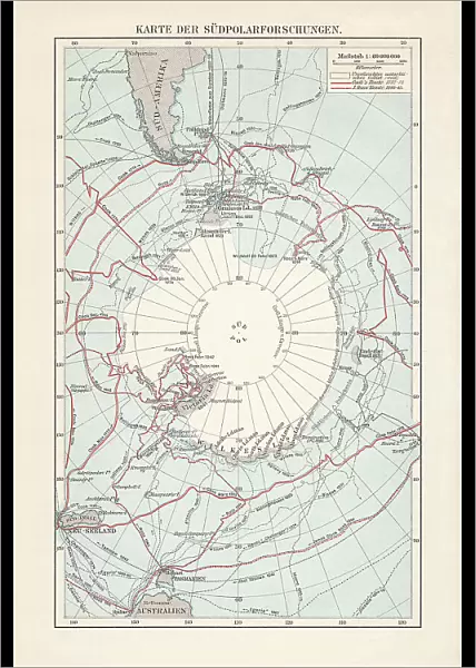
Poster Print : Antarctica map with sea routes of various explorers, lithograph, 1897


![]()
Poster Prints from Fine Art Storehouse
Antarctica map with sea routes of various explorers, lithograph, 1897
Historical map of the unexplored Antarctica with sea routes of various explorers, 18th - 19th century. Lithograph, published in 1897
Unleash your creativity and transform your space into a visual masterpiece!
ZU_09
Media ID 35843106
18th Century Adventure Antarctica Australia Explorer New Zealand Sea Passage South America South Pole Captain Cook Multi Colored White Color
A4 (29.7 x 21cm) Poster Print
Step back in time and explore the uncharted territories of Antarctica with our stunning lithograph print from the Media Storehouse's Historical Map Collection. This beautiful antique map, published in 1897, showcases the unexplored continent as it was known in the late 19th century. Trace the sea routes of famous explorers who dared to venture into the unknown, including Roald Amundsen, Robert Falcon Scott, and Ernest Shackleton. Add an air of adventure and historical intrigue to any room with this captivating piece from the Fine Art Storehouse.
Premium quality poster prints are printed on luxurious semi-gloss satin 270 gsm paper. Our meticulously crafted poster prints offer an affordable option for decorating any space, making them ideal for living rooms, bedrooms, offices and beyond. To ensure your poster arrives in good condition, we roll and send them in strong mailing tubes.
Poster prints are budget friendly enlarged prints in standard poster paper sizes (A0, A1, A2, A3 etc). Whilst poster paper is sometimes thinner and less durable than our other paper types, they are still ok for framing and should last many years. Our Archival Quality Photo Prints and Fine Art Paper Prints are printed on higher quality paper and the choice of which largely depends on your budget.
Estimated Image Size (if not cropped) is 20.4cm x 30.3cm (8" x 11.9")
Estimated Product Size is 21.6cm x 30.3cm (8.5" x 11.9")
These are individually made so all sizes are approximate
Artwork printed orientated as per the preview above, with portrait (vertical) orientation to match the source image.
FEATURES IN THESE COLLECTIONS
> Fine Art Storehouse
> Map
> Historical Maps
> Arts
> Artists
> W
> Charles White
> Maps and Charts
> Early Maps
> Maps and Charts
> Related Images
> Oceania
> Australia
> Related Images
> Oceania
> New Zealand
> Maps
> Oceania
> New Zealand
> Related Images
> South America
> Related Images
EDITORS COMMENTS
This stunning lithograph, published in 1897, offers a captivating glimpse into the unexplored territories of Antarctica during the late 18th and 19th centuries. The map, adorned with a crisp white background, vividly depicts the icy continent with intricate detail, its vast expanses of ice and water shimmering in blues and whites. At the heart of the map lies the elusive South Pole, a blank space of uncharted territory, beckoning the brave and the curious. The map is a testament to the spirit of adventure and exploration that defined this era. It marks the sea routes of some of the most renowned explorers of the time, including Captain James Cook and Charles Wilkes. Cook's explorations in the Pacific Ocean brought him close to Antarctica, but he was unable to reach the continent. Wilkes, on the other hand, led the United States Exploring Expedition to Antarctica in the 1830s and charted significant portions of the Antarctic coastline. The map also reveals the connections between Antarctica and other parts of the world, with sea passages leading from the Atlantic and Indian Oceans to the Southern Ocean that surrounds Antarctica. The map's vertical orientation and multi-colored engraving add to its aesthetic appeal, making it a fascinating historical document that transports us back in time to an era of discovery and exploration.
MADE IN AUSTRALIA
Safe Shipping with 30 Day Money Back Guarantee
FREE PERSONALISATION*
We are proud to offer a range of customisation features including Personalised Captions, Color Filters and Picture Zoom Tools
SECURE PAYMENTS
We happily accept a wide range of payment options so you can pay for the things you need in the way that is most convenient for you
* Options may vary by product and licensing agreement. Zoomed Pictures can be adjusted in the Cart.


