Fine Art Print > North America > Puerto Rico > Maps
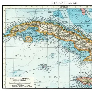
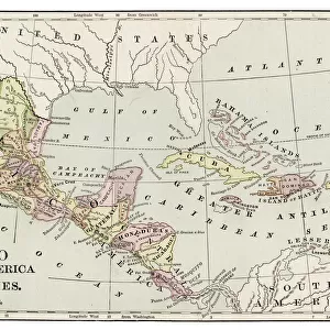
Fine Art Print : Cuba and Puerto Rico map 1898


![]()
Fine Art Prints from Fine Art Storehouse
Cuba and Puerto Rico map 1898
Unleash your creativity and transform your space into a visual masterpiece!
THEPALMER
Media ID 14757018
© This content is subject to copyright
20"x16" (+3" Border) Fine Art Print
Discover the rich history of the Caribbean with this stunning fine art print of the Cuba and Puerto Rico map from 1898 by THEPALMER, available at Media Storehouse. This intricately detailed map transports you back in time, providing a captivating visual representation of the political landscape during a pivotal moment in history. The muted colors and vintage aesthetic add an authentic touch, making this print an exquisite addition to any home or office decor. Bring a piece of the past into your space and ignite conversations with this captivating work of art.
20x16 image printed on 26x22 Fine Art Rag Paper with 3" (76mm) white border. Our Fine Art Prints are printed on 300gsm 100% acid free, PH neutral paper with archival properties. This printing method is used by museums and art collections to exhibit photographs and art reproductions.
Our fine art prints are high-quality prints made using a paper called Photo Rag. This 100% cotton rag fibre paper is known for its exceptional image sharpness, rich colors, and high level of detail, making it a popular choice for professional photographers and artists. Photo rag paper is our clear recommendation for a fine art paper print. If you can afford to spend more on a higher quality paper, then Photo Rag is our clear recommendation for a fine art paper print.
Estimated Image Size (if not cropped) is 50.8cm x 40.6cm (20" x 16")
Estimated Product Size is 66cm x 55.9cm (26" x 22")
These are individually made so all sizes are approximate
Artwork printed orientated as per the preview above, with landscape (horizontal) orientation to match the source image.
FEATURES IN THESE COLLECTIONS
> Maps and Charts
> Related Images
> North America
> Cuba
> Maps
> North America
> Cuba
> Related Images
> North America
> Puerto Rico
> Maps
> North America
> Puerto Rico
> Related Images
> Fine Art Storehouse
> Map
> Historical Maps
EDITORS COMMENTS
This print titled "Cuba and Puerto Rico map 1898" takes us back in time to a significant period in history. The image, captured by THEPALMER and available at Fine Art Storehouse, showcases an intricately detailed map from the year 1898. As we gaze upon this piece, we are transported to a time when Cuba and Puerto Rico were both under Spanish colonial rule. This particular era holds immense historical significance as it marks the end of the Spanish-American War and the beginning of a new chapter for these two Caribbean nations. The map itself is a testament to the artistry and precision of cartography during that era. Every contour, coastline, city, and river is meticulously depicted with remarkable attention to detail. It serves as a visual representation of how these islands were perceived over a century ago. Beyond its aesthetic appeal, this photograph also offers an opportunity for reflection on the complex histories shared between Cuba, Puerto Rico, Spain, and the United States during this transformative period. It invites us to explore questions about colonization, independence struggles, cultural identity shifts, and geopolitical changes that have shaped these countries' destinies. Whether you are an avid history enthusiast or simply appreciate fine art photography that tells compelling stories through visuals alone; this print is sure to captivate your imagination while serving as a timeless reminder of our interconnected pasts.
MADE IN AUSTRALIA
Safe Shipping with 30 Day Money Back Guarantee
FREE PERSONALISATION*
We are proud to offer a range of customisation features including Personalised Captions, Color Filters and Picture Zoom Tools
SECURE PAYMENTS
We happily accept a wide range of payment options so you can pay for the things you need in the way that is most convenient for you
* Options may vary by product and licensing agreement. Zoomed Pictures can be adjusted in the Cart.