Greetings Card > North America > Puerto Rico > Maps
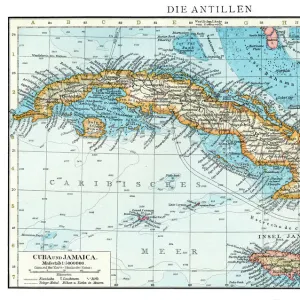
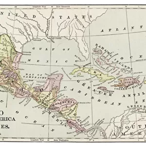
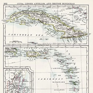
Greetings Card : Cuba and Puerto Rico map 1898


![]()
Cards from Fine Art Storehouse
Cuba and Puerto Rico map 1898
Unleash your creativity and transform your space into a visual masterpiece!
THEPALMER
Media ID 14757018
© This content is subject to copyright
Greetings Card (7"x5")
"Add a touch of historical charm to your greetings with our Cuba and Puerto Rico map 1898 card from ThePalmer at Media Storehouse. This exquisite fine art greeting card features an intricately detailed vintage map of Cuba and Puerto Rico from 1898. Perfect for history buffs or those with a love for travel, this card is a unique and thoughtful way to express your thoughts and feelings. Send a piece of the past with our Cuba and Puerto Rico map 1898 greeting card from ThePalmer at Media Storehouse."
Folded Greeting Cards (12.5x17.5 cm) have a laminate finish and are supplied with an envelope. The front and inside can be personalised with text in a selection of fonts, layouts and colours.
Greetings Cards suitable for Birthdays, Weddings, Anniversaries, Graduations, Thank You and much more
Estimated Product Size is 12.5cm x 17.5cm (4.9" x 6.9")
These are individually made so all sizes are approximate
Artwork printed orientated as per the preview above, with landscape (horizontal) or portrait (vertical) orientation to match the source image.
FEATURES IN THESE COLLECTIONS
> Fine Art Storehouse
> Map
> Historical Maps
> Maps and Charts
> Related Images
> North America
> Cuba
> Maps
> North America
> Cuba
> Related Images
> North America
> Puerto Rico
> Maps
> North America
> Puerto Rico
> Related Images
EDITORS COMMENTS
This print titled "Cuba and Puerto Rico map 1898" takes us back in time to a significant period in history. The image, captured by THEPALMER and available at Fine Art Storehouse, showcases an intricately detailed map from the year 1898. As we gaze upon this piece, we are transported to a time when Cuba and Puerto Rico were both under Spanish colonial rule. This particular era holds immense historical significance as it marks the end of the Spanish-American War and the beginning of a new chapter for these two Caribbean nations. The map itself is a testament to the artistry and precision of cartography during that era. Every contour, coastline, city, and river is meticulously depicted with remarkable attention to detail. It serves as a visual representation of how these islands were perceived over a century ago. Beyond its aesthetic appeal, this photograph also offers an opportunity for reflection on the complex histories shared between Cuba, Puerto Rico, Spain, and the United States during this transformative period. It invites us to explore questions about colonization, independence struggles, cultural identity shifts, and geopolitical changes that have shaped these countries' destinies. Whether you are an avid history enthusiast or simply appreciate fine art photography that tells compelling stories through visuals alone; this print is sure to captivate your imagination while serving as a timeless reminder of our interconnected pasts.
MADE IN AUSTRALIA
Safe Shipping with 30 Day Money Back Guarantee
FREE PERSONALISATION*
We are proud to offer a range of customisation features including Personalised Captions, Color Filters and Picture Zoom Tools
SECURE PAYMENTS
We happily accept a wide range of payment options so you can pay for the things you need in the way that is most convenient for you
* Options may vary by product and licensing agreement. Zoomed Pictures can be adjusted in the Cart.