Fine Art Print > North America > United States of America > New York > New York > Maps
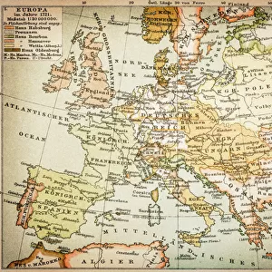
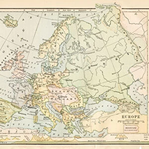
Fine Art Print : Map of Europe 1899


![]()
Fine Art Prints from Fine Art Storehouse
Map of Europe 1899
Maurys Geographical Series Manual of Geography - New York 1899
Unleash your creativity and transform your space into a visual masterpiece!
THEPALMER
Media ID 19834487
© 2014 Roberto Adrian Photography
20"x16" (+3" Border) Fine Art Print
Discover the captivating allure of history with our exquisite Map of Europe 1899 by THEPALER from the Fine Art Storehouse collection. Hailing from Maurys Geographical Series Manual of Geography published in New York, 1899, this fine art print transports you back in time. Each intricate detail in the map's elegant design reveals a snapshot of Europe's geography during a pivotal era. Add a touch of historical charm to your home or office with this stunning, vintage map print.
20x16 image printed on 26x22 Fine Art Rag Paper with 3" (76mm) white border. Our Fine Art Prints are printed on 300gsm 100% acid free, PH neutral paper with archival properties. This printing method is used by museums and art collections to exhibit photographs and art reproductions.
Our fine art prints are high-quality prints made using a paper called Photo Rag. This 100% cotton rag fibre paper is known for its exceptional image sharpness, rich colors, and high level of detail, making it a popular choice for professional photographers and artists. Photo rag paper is our clear recommendation for a fine art paper print. If you can afford to spend more on a higher quality paper, then Photo Rag is our clear recommendation for a fine art paper print.
Estimated Image Size (if not cropped) is 49.1cm x 40.6cm (19.3" x 16")
Estimated Product Size is 66cm x 55.9cm (26" x 22")
These are individually made so all sizes are approximate
Artwork printed orientated as per the preview above, with landscape (horizontal) orientation to match the source image.
FEATURES IN THESE COLLECTIONS
> Europe
> Related Images
> Maps and Charts
> Related Images
> North America
> United States of America
> New York
> New York
> Maps
> North America
> United States of America
> New York
> Related Images
> Fine Art Storehouse
> Map
> Historical Maps
EDITORS COMMENTS
This print titled "Map of Europe 1899" takes us on a journey back in time to the turn of the 20th century. A part of Maurys Geographical Series Manual of Geography, published in New York in 1899, this exquisite piece captures the essence and intricacies of Europe during that era. The map itself is a testament to the artistry and precision involved in cartography at the time. Every detail has been meticulously crafted, showcasing borders, cities, rivers, and mountain ranges with remarkable accuracy. The vibrant colors used bring life to each country and region depicted on this historical document. As we gaze upon this map, we are transported to an era when Europe was undergoing significant political changes and cultural transformations. It serves as a window into a world where empires rose and fell, alliances were forged or broken, and new nations emerged from centuries-old conflicts. Beyond its historical significance lies its aesthetic appeal; it exudes an aura of elegance that only vintage maps possess. This particular print by THEPALMER offers not just educational value but also serves as a stunning piece of wall art for any history enthusiast or lover of classic design. Whether displayed in homes or offices alike, this Map of Europe 1899 invites viewers to explore the past while appreciating the beauty found within these carefully drawn lines.
MADE IN AUSTRALIA
Safe Shipping with 30 Day Money Back Guarantee
FREE PERSONALISATION*
We are proud to offer a range of customisation features including Personalised Captions, Color Filters and Picture Zoom Tools
SECURE PAYMENTS
We happily accept a wide range of payment options so you can pay for the things you need in the way that is most convenient for you
* Options may vary by product and licensing agreement. Zoomed Pictures can be adjusted in the Cart.