Fine Art Print > Europe > United Kingdom > England > Maps
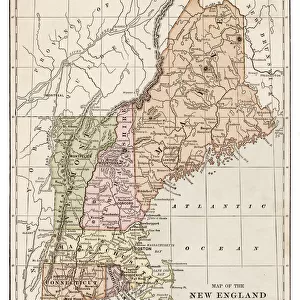
Fine Art Print : Map of New England states 1886


![]()
Fine Art Prints from Fine Art Storehouse
Map of New England states 1886
Unleash your creativity and transform your space into a visual masterpiece!
THEPALMER
Media ID 14757036
© This content is subject to copyright
20"x16" (+3" Border) Fine Art Print
Discover the rich history of New England with this stunning 1886 Map of New England States by THEPALMER from our Fine Art Prints collection. This intricately detailed vintage map transports you back in time, showcasing the distinct borders and geographical features of the six New England states during a bygone era. Add an elegant touch of history to your home or office with this beautifully preserved piece of cartographical art.
20x16 image printed on 26x22 Fine Art Rag Paper with 3" (76mm) white border. Our Fine Art Prints are printed on 300gsm 100% acid free, PH neutral paper with archival properties. This printing method is used by museums and art collections to exhibit photographs and art reproductions.
Our fine art prints are high-quality prints made using a paper called Photo Rag. This 100% cotton rag fibre paper is known for its exceptional image sharpness, rich colors, and high level of detail, making it a popular choice for professional photographers and artists. Photo rag paper is our clear recommendation for a fine art paper print. If you can afford to spend more on a higher quality paper, then Photo Rag is our clear recommendation for a fine art paper print.
Estimated Image Size (if not cropped) is 40.6cm x 50.8cm (16" x 20")
Estimated Product Size is 55.9cm x 66cm (22" x 26")
These are individually made so all sizes are approximate
Artwork printed orientated as per the preview above, with portrait (vertical) orientation to match the source image.
FEATURES IN THESE COLLECTIONS
> Europe
> United Kingdom
> England
> Maps
> Europe
> United Kingdom
> England
> Posters
> Europe
> United Kingdom
> England
> Related Images
> Maps and Charts
> Related Images
> Fine Art Storehouse
> Map
> Historical Maps
EDITORS COMMENTS
This print showcases a remarkable piece of history, the "Map of New England states 1886" by THEPALMER. Transporting us back to the late 19th century, this meticulously detailed map offers a glimpse into the past and invites us to explore the enchanting region of New England. The intricate cartography captures the essence of this northeastern corner of the United States with stunning precision. From Maine's rugged coastline to Vermont's picturesque mountains, every contour and feature is beautifully depicted. The map not only serves as a navigational tool but also reveals fascinating insights into how these states were interconnected during that era. THEPALMER's artistic touch shines through in this photo print, which expertly preserves every delicate line and vibrant color from the original artwork. The attention to detail allows viewers to appreciate both its historical significance and aesthetic appeal. Whether you are an avid historian or simply captivated by vintage maps, this exquisite piece will undoubtedly spark curiosity and conversation. It serves as a reminder of our ever-evolving world while honoring the rich heritage embedded within these New England states. Displaying "Map of New England states 1886" in your home or office brings forth an air of sophistication blended with nostalgia. It is not just a mere decoration; it is an invitation to embark on a journey through time – exploring forgotten towns, tracing old trade routes, and immersing oneself in the charm that has defined New England for centuries.
MADE IN AUSTRALIA
Safe Shipping with 30 Day Money Back Guarantee
FREE PERSONALISATION*
We are proud to offer a range of customisation features including Personalised Captions, Color Filters and Picture Zoom Tools
SECURE PAYMENTS
We happily accept a wide range of payment options so you can pay for the things you need in the way that is most convenient for you
* Options may vary by product and licensing agreement. Zoomed Pictures can be adjusted in the Cart.