Jigsaw Puzzle > Europe > United Kingdom > England > Maps
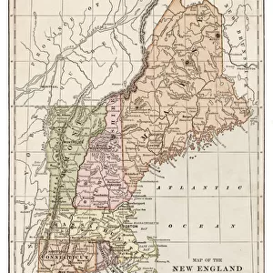
Jigsaw Puzzle : Map of New England states 1886


![]()
Jigsaw Puzzles from Fine Art Storehouse
Map of New England states 1886
Unleash your creativity and transform your space into a visual masterpiece!
THEPALMER
Media ID 14757036
© This content is subject to copyright
Jigsaw Puzzle (500 Pieces)
Discover the rich history of New England with our captivating jigsaw puzzle from ThePalmer's Fine Art Storehouse collection. Featuring a detailed map of the New England states from 1886, this puzzle invites you on a journey through time. Engage your mind and enhance your problem-solving skills as you piece together this intricate and beautifully illustrated puzzle. A perfect activity for families or individuals, this puzzle makes for a wonderful addition to any home or office, and is sure to be a conversation starter. Immerse yourself in the intricacies of the past, and bring history to life with our Media Storehouse Map of New England states 1886 jigsaw puzzle.
500 piece puzzles are custom made in Australia and hand-finished on 100% recycled 1.6mm thick laminated puzzle boards. There is a level of repetition in jigsaw shapes with each matching piece away from its pair. The completed puzzle measures 40x51cm and is delivered packaged in an attractive presentation box specially designed to fit most mail slots with a unique magnetic lid
Jigsaw Puzzles are an ideal gift for any occasion
Estimated Product Size is 40.3cm x 50.7cm (15.9" x 20")
These are individually made so all sizes are approximate
Artwork printed orientated as per the preview above, with landscape (horizontal) or portrait (vertical) orientation to match the source image.
FEATURES IN THESE COLLECTIONS
> Fine Art Storehouse
> Map
> Historical Maps
> Europe
> United Kingdom
> England
> Maps
> Europe
> United Kingdom
> England
> Posters
> Europe
> United Kingdom
> England
> Related Images
> Maps and Charts
> Related Images
EDITORS COMMENTS
This print showcases a remarkable piece of history, the "Map of New England states 1886" by THEPALMER. Transporting us back to the late 19th century, this meticulously detailed map offers a glimpse into the past and invites us to explore the enchanting region of New England. The intricate cartography captures the essence of this northeastern corner of the United States with stunning precision. From Maine's rugged coastline to Vermont's picturesque mountains, every contour and feature is beautifully depicted. The map not only serves as a navigational tool but also reveals fascinating insights into how these states were interconnected during that era. THEPALMER's artistic touch shines through in this photo print, which expertly preserves every delicate line and vibrant color from the original artwork. The attention to detail allows viewers to appreciate both its historical significance and aesthetic appeal. Whether you are an avid historian or simply captivated by vintage maps, this exquisite piece will undoubtedly spark curiosity and conversation. It serves as a reminder of our ever-evolving world while honoring the rich heritage embedded within these New England states. Displaying "Map of New England states 1886" in your home or office brings forth an air of sophistication blended with nostalgia. It is not just a mere decoration; it is an invitation to embark on a journey through time – exploring forgotten towns, tracing old trade routes, and immersing oneself in the charm that has defined New England for centuries.
MADE IN AUSTRALIA
Safe Shipping with 30 Day Money Back Guarantee
FREE PERSONALISATION*
We are proud to offer a range of customisation features including Personalised Captions, Color Filters and Picture Zoom Tools
SECURE PAYMENTS
We happily accept a wide range of payment options so you can pay for the things you need in the way that is most convenient for you
* Options may vary by product and licensing agreement. Zoomed Pictures can be adjusted in the Cart.