Fine Art Print > Maps and Charts > Africa
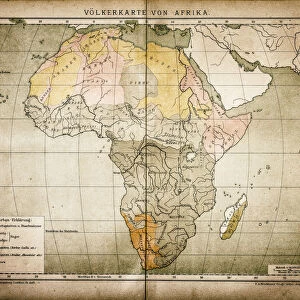
Fine Art Print : Ethnographic map of Africa from 1898


![]()
Fine Art Prints from Fine Art Storehouse
Ethnographic map of Africa from 1898
Illustration of a Ethnographic map of Africa
Unleash your creativity and transform your space into a visual masterpiece!
Nastasic
Media ID 15489841
© This content is subject to copyright
20"x16" (+3" Border) Fine Art Print
Discover the rich cultural heritage of Africa through the captivating lens of history with our Ethnographic Map of Africa from 1898 by Nastasic, available at Media Storehouse. This exquisite fine art print showcases intricate details of African tribes and territories as they were documented during a pivotal time in history. Bring the stories of the past into your home or office, and add an authentic and educational touch to your decor. Order your Ethnographic Map of Africa fine art print today from Media Storehouse and embark on a journey through time.
20x16 image printed on 26x22 Fine Art Rag Paper with 3" (76mm) white border. Our Fine Art Prints are printed on 300gsm 100% acid free, PH neutral paper with archival properties. This printing method is used by museums and art collections to exhibit photographs and art reproductions.
Our fine art prints are high-quality prints made using a paper called Photo Rag. This 100% cotton rag fibre paper is known for its exceptional image sharpness, rich colors, and high level of detail, making it a popular choice for professional photographers and artists. Photo rag paper is our clear recommendation for a fine art paper print. If you can afford to spend more on a higher quality paper, then Photo Rag is our clear recommendation for a fine art paper print.
Estimated Image Size (if not cropped) is 50.5cm x 40.6cm (19.9" x 16")
Estimated Product Size is 66cm x 55.9cm (26" x 22")
These are individually made so all sizes are approximate
Artwork printed orientated as per the preview above, with landscape (horizontal) orientation to match the source image.
FEATURES IN THESE COLLECTIONS
> Africa
> Related Images
> Maps and Charts
> Related Images
> Fine Art Storehouse
> Map
> Map Illustrations
EDITORS COMMENTS
This print showcases an extraordinary piece of history - an ethnographic map of Africa from 1898. Created by the talented artist Nastasic, this illustration offers a fascinating glimpse into the diverse cultures and tribes that inhabited the African continent during that era. The intricate details and vibrant colors used in this artwork bring to life the rich tapestry of African ethnic groups, highlighting their unique traditions, languages, and territories. From the Berbers in North Africa to the Zulu people in Southern Africa, every corner of this vast land is represented with utmost precision. As we gaze upon this remarkable map, we are reminded of how interconnected humanity truly is. It serves as a powerful reminder that despite our differences, we all share a common heritage rooted in our respective cultures and histories. Beyond its aesthetic appeal, this photograph print also holds immense educational value. It allows us to delve deeper into Africa's past and gain a better understanding of its complex social fabric. Whether displayed in classrooms or personal spaces, it sparks curiosity and encourages exploration. Nastasic's artistic prowess shines through every brushstroke on display here. This ethereal image transports us back in time while simultaneously celebrating the enduring beauty and diversity found within one of Earth's most enchanting continents – Africa.
MADE IN AUSTRALIA
Safe Shipping with 30 Day Money Back Guarantee
FREE PERSONALISATION*
We are proud to offer a range of customisation features including Personalised Captions, Color Filters and Picture Zoom Tools
SECURE PAYMENTS
We happily accept a wide range of payment options so you can pay for the things you need in the way that is most convenient for you
* Options may vary by product and licensing agreement. Zoomed Pictures can be adjusted in the Cart.