Greetings Card > Maps and Charts > Africa
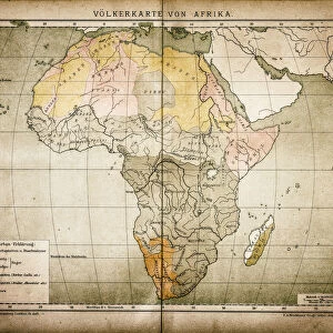
Greetings Card : Ethnographic map of Africa from 1898


![]()
Cards from Fine Art Storehouse
Ethnographic map of Africa from 1898
Illustration of a Ethnographic map of Africa
Unleash your creativity and transform your space into a visual masterpiece!
Nastasic
Media ID 15489841
© This content is subject to copyright
Greetings Card (7"x5")
Add a touch of historical charm to your greetings with Media Storehouse's unique Ethnographic Map of Africa Greeting Cards. This beautifully intricate design, inspired by the 1898 Ethnographic Map of Africa by Nastasic from our Fine Art Storehouse, transports you back in time. Each card is a work of art, featuring the detailed illustrations and vibrant colors of the map, making for a thoughtful and distinctive way to express your sentiments. Perfect for any occasion, these cards are sure to impress and delight.
Folded Greeting Cards (12.5x17.5 cm) have a laminate finish and are supplied with an envelope. The front and inside can be personalised with text in a selection of fonts, layouts and colours.
Greetings Cards suitable for Birthdays, Weddings, Anniversaries, Graduations, Thank You and much more
Estimated Product Size is 12.5cm x 17.5cm (4.9" x 6.9")
These are individually made so all sizes are approximate
Artwork printed orientated as per the preview above, with landscape (horizontal) or portrait (vertical) orientation to match the source image.
FEATURES IN THESE COLLECTIONS
> Fine Art Storehouse
> Map
> Map Illustrations
> Africa
> Related Images
> Maps and Charts
> Related Images
EDITORS COMMENTS
This print showcases an extraordinary piece of history - an ethnographic map of Africa from 1898. Created by the talented artist Nastasic, this illustration offers a fascinating glimpse into the diverse cultures and tribes that inhabited the African continent during that era. The intricate details and vibrant colors used in this artwork bring to life the rich tapestry of African ethnic groups, highlighting their unique traditions, languages, and territories. From the Berbers in North Africa to the Zulu people in Southern Africa, every corner of this vast land is represented with utmost precision. As we gaze upon this remarkable map, we are reminded of how interconnected humanity truly is. It serves as a powerful reminder that despite our differences, we all share a common heritage rooted in our respective cultures and histories. Beyond its aesthetic appeal, this photograph print also holds immense educational value. It allows us to delve deeper into Africa's past and gain a better understanding of its complex social fabric. Whether displayed in classrooms or personal spaces, it sparks curiosity and encourages exploration. Nastasic's artistic prowess shines through every brushstroke on display here. This ethereal image transports us back in time while simultaneously celebrating the enduring beauty and diversity found within one of Earth's most enchanting continents – Africa.
MADE IN AUSTRALIA
Safe Shipping with 30 Day Money Back Guarantee
FREE PERSONALISATION*
We are proud to offer a range of customisation features including Personalised Captions, Color Filters and Picture Zoom Tools
SECURE PAYMENTS
We happily accept a wide range of payment options so you can pay for the things you need in the way that is most convenient for you
* Options may vary by product and licensing agreement. Zoomed Pictures can be adjusted in the Cart.