
Fine Art Print > Granger Art on Demand > Maps
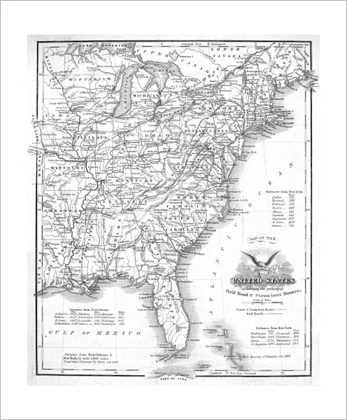
Fine Art Print : RAILROAD & CANAL MAP, 1863. A Railroad and Canal map of the Eastern United States, 1863


![]()
Fine Art Prints from Granger
RAILROAD & CANAL MAP, 1863. A Railroad and Canal map of the Eastern United States, 1863
RAILROAD & CANAL MAP, 1863.
A Railroad and Canal map of the Eastern United States, 1863
Granger holds millions of images spanning more than 25,000 years of world history, from before the Stone Age to the dawn of the Space Age
Media ID 12321149
1863 Arkansas Atlantic Ocean Canada Canal Coast Connecticut Delaware Eastern Florida Georgia Gulf Of Mexico Iowa Kentucky Louisiana Maine Massachusetts Michigan Minnesota Mississippi Missouri New Hampshire New Jersey New York North Carolina Ohio Pennsylvania Railroad Rhode Island Seashore South Carolina Tennessee United States Virginia West Virginia Southeast
20"x16" (+3" Border) Fine Art Print
Step back in time with our exquisite Fine Art Print from the Media Storehouse collection. This captivating Railroad and Canal map of the Eastern United States, originally published in 1863, offers a fascinating glimpse into the transportation infrastructure of the past. Detailed illustrations of railroad lines, canals, and waterways provide a unique perspective on the historical development of transportation networks in the region. Bring this intriguing piece of American history into your home or office and add an element of timeless charm to your decor. Order your Fine Art Print of RAILROAD & CANAL MAP, 1863 today from Granger Art on Demand.
20x16 image printed on 26x22 Fine Art Rag Paper with 3" (76mm) white border. Our Fine Art Prints are printed on 300gsm 100% acid free, PH neutral paper with archival properties. This printing method is used by museums and art collections to exhibit photographs and art reproductions.
Our fine art prints are high-quality prints made using a paper called Photo Rag. This 100% cotton rag fibre paper is known for its exceptional image sharpness, rich colors, and high level of detail, making it a popular choice for professional photographers and artists. Photo rag paper is our clear recommendation for a fine art paper print. If you can afford to spend more on a higher quality paper, then Photo Rag is our clear recommendation for a fine art paper print.
Estimated Image Size (if not cropped) is 40.6cm x 48.8cm (16" x 19.2")
Estimated Product Size is 55.9cm x 66cm (22" x 26")
These are individually made so all sizes are approximate
Artwork printed orientated as per the preview above, with portrait (vertical) orientation to match the source image.
RAILROAD & CANAL MAP, 1863 - A Glimpse into America's Transportation Network in the 19th Century
EDITORS COMMENTS
. This print showcases a meticulously detailed Railroad and Canal map of the Eastern United States from the year 1863. The map offers an intriguing glimpse into America's evolving transportation network during this pivotal period in history. Spanning across various states, from Maine to Florida and westward to Iowa, this comprehensive map highlights the extensive railroad lines and intricate canal systems that connected major cities and regions. It serves as a testament to the ambitious engineering feats undertaken by early American pioneers. The map reveals how these vital transport routes facilitated trade, commerce, and travel between different parts of the country. From bustling coastal areas along the Atlantic Ocean to inland territories near rivers like Mississippi and Missouri, it is evident that railroads played a crucial role in shaping economic growth and societal development. As you explore this vintage masterpiece further, take note of significant landmarks such as towns, rivers, mountains, and state borders carefully etched onto its surface. Each detail tells a story about America's rich history while offering valuable insights into how people navigated through vast landscapes more than a century ago. Whether you are an avid historian or simply intrigued by cartography, this remarkable Railroad & Canal Map print transports you back in time to an era when railroads were transforming both geography and society itself.
MADE IN AUSTRALIA
Safe Shipping with 30 Day Money Back Guarantee
FREE PERSONALISATION*
We are proud to offer a range of customisation features including Personalised Captions, Color Filters and Picture Zoom Tools
SECURE PAYMENTS
We happily accept a wide range of payment options so you can pay for the things you need in the way that is most convenient for you
* Options may vary by product and licensing agreement. Zoomed Pictures can be adjusted in the Cart.
