Fine Art Print > Europe > United Kingdom > England > Maps
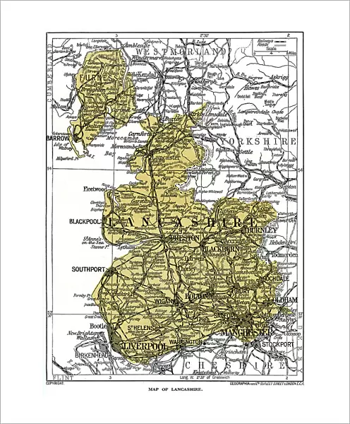
Fine Art Print : Map of Lancashire, 1924-1926


![]()
Fine Art Prints from Heritage Images
Map of Lancashire, 1924-1926
Map of Lancashire, 1924-1926. A print from Hutchinsons Britain Beautiful, edited by Walter Hutchinson, volume III, 1924-1926
Heritage Images features heritage image collections
Media ID 14924083
© The Print Collector / Heritage-Images
Cartography County Lancashire Map Making Print Collector8
20"x16" (+3" Border) Fine Art Print
Discover the rich history of Lancashire with this exquisite fine art print from Media Storehouse. Originating from Hutchinsons Britain Beautiful, edited by Walter Hutchinson, this rare map dates back to 1924-1926. The intricate details of the county's geography and towns are beautifully rendered, offering a captivating glimpse into the past. Bring the charm of vintage cartography into your home or office with this unique and authentic piece.
20x16 image printed on 26x22 Fine Art Rag Paper with 3" (76mm) white border. Our Fine Art Prints are printed on 300gsm 100% acid free, PH neutral paper with archival properties. This printing method is used by museums and art collections to exhibit photographs and art reproductions.
Our fine art prints are high-quality prints made using a paper called Photo Rag. This 100% cotton rag fibre paper is known for its exceptional image sharpness, rich colors, and high level of detail, making it a popular choice for professional photographers and artists. Photo rag paper is our clear recommendation for a fine art paper print. If you can afford to spend more on a higher quality paper, then Photo Rag is our clear recommendation for a fine art paper print.
Estimated Image Size (if not cropped) is 36.5cm x 50.8cm (14.4" x 20")
Estimated Product Size is 55.9cm x 66cm (22" x 26")
These are individually made so all sizes are approximate
Artwork printed orientated as per the preview above, with portrait (vertical) orientation to match the source image.
FEATURES IN THESE COLLECTIONS
> Europe
> United Kingdom
> England
> Lancashire
> Related Images
> Europe
> United Kingdom
> England
> Maps
> Maps and Charts
> Related Images
EDITORS COMMENTS
This print showcases a Map of Lancashire, dating back to the years 1924-1926. The map is a part of Hutchinsons Britain Beautiful, an esteemed publication edited by Walter Hutchinson during that era. A testament to British cartography and geography, this colorful representation provides insight into the county's location and highlights its distinctive features. The vibrant hues used in this map bring Lancashire to life, capturing the essence of England in the 1920s. It serves as a valuable historical artifact, offering glimpses into how boundaries were defined and territories were demarcated during that time period. Created by an unknown artist or creator, this print exemplifies their skillful craftsmanship in map making. Every detail has been meticulously rendered to ensure accuracy and clarity for viewers seeking knowledge about Lancashire's landscape. As we delve into this image from The Print Collector collection, we are transported back to a significant moment in history when maps played an integral role in understanding our surroundings. This particular piece allows us to appreciate both the artistry involved in cartography and the importance of preserving such cultural treasures. Through its vivid colors and intricate details, this Map of Lancashire invites us on a journey through time while reminding us of the rich heritage embedded within these ancient landscapes.
MADE IN AUSTRALIA
Safe Shipping with 30 Day Money Back Guarantee
FREE PERSONALISATION*
We are proud to offer a range of customisation features including Personalised Captions, Color Filters and Picture Zoom Tools
SECURE PAYMENTS
We happily accept a wide range of payment options so you can pay for the things you need in the way that is most convenient for you
* Options may vary by product and licensing agreement. Zoomed Pictures can be adjusted in the Cart.