Fine Art Print > Arts > Photorealistic artworks > Detailed art pieces > Masterful detailing in art
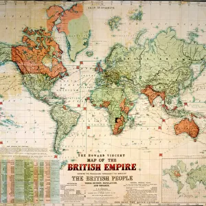
Fine Art Print : Map of The British Empire by Fullarton & Co 1850


![]()
Fine Art Prints from MapSeeker
Map of The British Empire by Fullarton & Co 1850
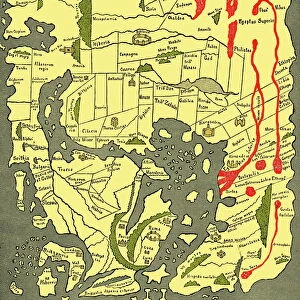
Fine reproduction of the attractive World Map showing the British Empire. Mapmaker John Bartholomew and publishers Fullarton were then the first to use red or pink to indicate British possessions around the world, a feature which became common to most maps for the next 100 years. In this map, which dates back to the 1850AEs states in notes at the top of the map oThe British Possessions are engraved in a bolder character and coloured Redo. The map is also framed by idealized images of friendly encounters between British colonists and indigenous inhabitants in four different parts of the Globe: Australia, North America, British Asia, East Inidican islands and the Cape Colony in Southern Africa. It is highly detailed and decorative and it appeared in FullartonAEs Royal Illustrated Atlas which was first published in 1864 after being issued in 27 parts from 1854-62. The tables shown include the size and population of the British possessions at the time of publication
Welcome to the Mapseeker Image library and enter an historic gateway to one of the largest on-line collections of Historic Maps, Nostalgic Views, Vista's and Panorama's from a World gone by.
Media ID 20347041
Map Of The World Old Map Of The World The World World Map British Empire
21"x14" (+3" Border) Fine Art Print
Discover the rich history of the British Empire with our exquisite Fine Art Print of the Map of The British Empire by Fullarton & Co, 1850 from MapSeeker. This stunning reproduction showcases intricate detail and vibrant colors, with the mapmakers John Bartholomew and publishers Fullarton being the first to use pink or red to indicate British territories. A captivating addition to any home or office, this fine art print transports you back in time, making it an ideal gift for history enthusiasts or those who appreciate the beauty of vintage maps.
21x14 image printed on 27x20 Fine Art Rag Paper with 3" (76mm) white border. Our Fine Art Prints are printed on 300gsm 100% acid free, PH neutral paper with archival properties. This printing method is used by museums and art collections to exhibit photographs and art reproductions.
Our fine art prints are high-quality prints made using a paper called Photo Rag. This 100% cotton rag fibre paper is known for its exceptional image sharpness, rich colors, and high level of detail, making it a popular choice for professional photographers and artists. Photo rag paper is our clear recommendation for a fine art paper print. If you can afford to spend more on a higher quality paper, then Photo Rag is our clear recommendation for a fine art paper print.
Estimated Image Size (if not cropped) is 53.3cm x 35.5cm (21" x 14")
Estimated Product Size is 68.6cm x 50.8cm (27" x 20")
These are individually made so all sizes are approximate
Artwork printed orientated as per the preview above, with landscape (horizontal) orientation to match the source image.
FEATURES IN THESE COLLECTIONS
> Arts
> Photorealistic artworks
> Detailed art pieces
> Masterful detailing in art
> Asia
> East Timor
> Maps
> Asia
> East Timor
> Related Images
> Maps and Charts
> British Empire Maps
> Maps and Charts
> Related Images
> Maps and Charts
> World
EDITORS COMMENTS
This print showcases a fine reproduction of the Map of The British Empire by Fullarton & Co from 1850. Renowned mapmaker John Bartholomew and publishers Fullarton were pioneers in their use of red or pink to highlight British possessions across the globe, a convention that would endure for the next century. This particular map, dating back to the 1850s, proudly declares at its summit that "The British Possessions are engraved in a bolder character and coloured Red". What sets this map apart is its exquisite attention to detail and decorative elements. Framing the edges are idyllic depictions of harmonious encounters between British colonists and indigenous inhabitants in various regions: Australia, North America, British Asia, East Indian islands, and the Cape Colony in Southern Africa. These images serve as reminders of Britain's global influence during this era. Originally featured in Fullarton's Royal Illustrated Atlas published in 1864 (after being issued in parts from 1854-62), this map not only provides geographical information but also includes tables presenting the size and population of each British possession at that time. With its historical significance as one of the earliest maps utilizing color-coded indicators for colonial territories and its striking visual appeal through intricate illustrations, this print offers an intriguing glimpse into an era when Britannia ruled over vast expanses around the world.
MADE IN AUSTRALIA
Safe Shipping with 30 Day Money Back Guarantee
FREE PERSONALISATION*
We are proud to offer a range of customisation features including Personalised Captions, Color Filters and Picture Zoom Tools
SECURE PAYMENTS
We happily accept a wide range of payment options so you can pay for the things you need in the way that is most convenient for you
* Options may vary by product and licensing agreement. Zoomed Pictures can be adjusted in the Cart.