Fine Art Print > Europe > United Kingdom > England > Maps
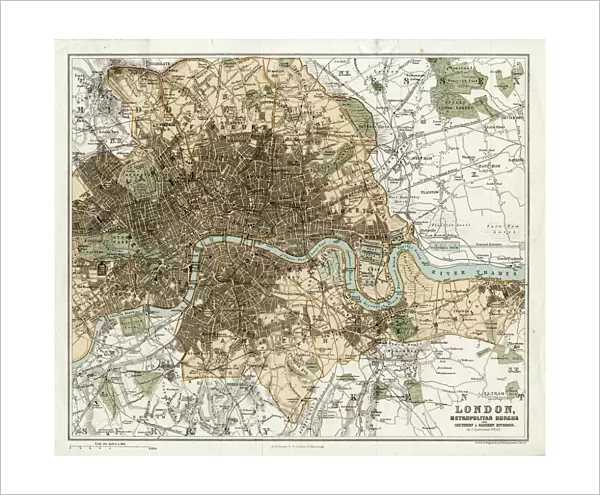
Fine Art Print : MAP / LONDON 1878


![]()
Fine Art Prints from Mary Evans Picture Library
MAP / LONDON 1878
Map of London and its suburbs
Mary Evans Picture Library makes available wonderful images created for people to enjoy over the centuries
Media ID 608786
© Mary Evans Picture Library 2015 - https://copyrighthub.org/s0/hub1/creation/maryevans/MaryEvansPictureID/10113947
20"x16" (+3" Border) Fine Art Print
Discover the captivating beauty of history with our exquisite range of Fine Art Prints from Mary Evans Picture Library. This particular piece, titled "MAP / LONDON 1878," transports you back in time to the bustling streets of London over a century ago. The intricate details of the map reveal the layout of the city and its suburbs, offering a fascinating glimpse into the past. Each print is meticulously reproduced from original sources, ensuring the highest quality and authenticity. Bring a piece of history into your home or office and add a touch of timeless elegance to your space.
20x16 image printed on 26x22 Fine Art Rag Paper with 3" (76mm) white border. Our Fine Art Prints are printed on 300gsm 100% acid free, PH neutral paper with archival properties. This printing method is used by museums and art collections to exhibit photographs and art reproductions.
Our fine art prints are high-quality prints made using a paper called Photo Rag. This 100% cotton rag fibre paper is known for its exceptional image sharpness, rich colors, and high level of detail, making it a popular choice for professional photographers and artists. Photo rag paper is our clear recommendation for a fine art paper print. If you can afford to spend more on a higher quality paper, then Photo Rag is our clear recommendation for a fine art paper print.
Estimated Image Size (if not cropped) is 47.7cm x 40.6cm (18.8" x 16")
Estimated Product Size is 66cm x 55.9cm (26" x 22")
These are individually made so all sizes are approximate
Artwork printed orientated as per the preview above, with landscape (horizontal) orientation to match the source image.
FEATURES IN THESE COLLECTIONS
> Europe
> United Kingdom
> England
> London
> Related Images
> Europe
> United Kingdom
> England
> Maps
> Europe
> United Kingdom
> England
> Posters
> Europe
> United Kingdom
> England
> Related Images
> Maps and Charts
> Early Maps
> Maps and Charts
> Related Images
EDITORS COMMENTS
This stunning print of a Map of London and its suburbs from 1878 offers a fascinating glimpse into the history and development of England's capital city. The intricate details captured in this map provide a snapshot of London during a time when it was rapidly expanding and evolving.
As we study the various neighborhoods, streets, and landmarks depicted on this historical map, we can't help but marvel at how much has changed over the years. From bustling city centers to quaint suburban villages, each area tells its own unique story about life in Victorian-era London.
The craftsmanship and attention to detail that went into creating this map are truly remarkable. Every street corner, park, and building is meticulously illustrated, giving us an insight into what life was like for Londoners more than a century ago.
Whether you're a history buff or simply appreciate beautiful works of art, this Map of London from 1878 is sure to captivate your imagination. It serves as a reminder of how far London has come since then while also preserving the charm and character that have made it one of the world's most iconic cities.
Mary Evans Picture Library has once again curated an exceptional piece that not only educates but also inspires us to explore the rich tapestry of London's past.
MADE IN AUSTRALIA
Safe Shipping with 30 Day Money Back Guarantee
FREE PERSONALISATION*
We are proud to offer a range of customisation features including Personalised Captions, Color Filters and Picture Zoom Tools
SECURE PAYMENTS
We happily accept a wide range of payment options so you can pay for the things you need in the way that is most convenient for you
* Options may vary by product and licensing agreement. Zoomed Pictures can be adjusted in the Cart.