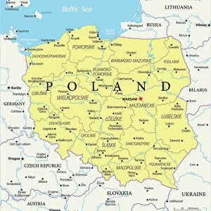
Fine Art Print > Europe > Poland > Maps
Fine Art Print : Map / Europe / Germany 1871


![]()
Fine Art Prints from Mary Evans Picture Library
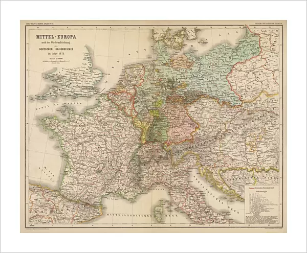
Map / Europe / Germany 1871
Imperial Germany after the Franco- Prussian War, showing Alsace and Lorraine as part of the country, not to mention huge chunks of Poland in East Prussia
Mary Evans Picture Library makes available wonderful images created for people to enjoy over the centuries
Media ID 594581
© Mary Evans Picture Library 2015 - https://copyrighthub.org/s0/hub1/creation/maryevans/MaryEvansPictureID/10046923
1871 Alsace Franco Huge Lorraine Maps Mention Poland Prussia Prussian Chunks
20"x16" (+3" Border) Fine Art Print
Discover the rich history of Imperial Germany with this stunning fine art print from the Media Storehouse collection. Featuring the captivating map "Map / Europe / Germany 1871" from Mary Evans Picture Library, this print showcases the political landscape of Europe after the Franco-Prussian War. Witness the expansion of the German Empire with Alsace and Lorraine incorporated, as well as significant territories in Poland becoming part of East Prussia. This exquisite print is not only a beautiful addition to any wall, but also a fascinating glimpse into historical geography. Order yours today and bring a piece of history into your home or office.
20x16 image printed on 26x22 Fine Art Rag Paper with 3" (76mm) white border. Our Fine Art Prints are printed on 300gsm 100% acid free, PH neutral paper with archival properties. This printing method is used by museums and art collections to exhibit photographs and art reproductions.
Our fine art prints are high-quality prints made using a paper called Photo Rag. This 100% cotton rag fibre paper is known for its exceptional image sharpness, rich colors, and high level of detail, making it a popular choice for professional photographers and artists. Photo rag paper is our clear recommendation for a fine art paper print. If you can afford to spend more on a higher quality paper, then Photo Rag is our clear recommendation for a fine art paper print.
Estimated Image Size (if not cropped) is 50.8cm x 40.6cm (20" x 16")
Estimated Product Size is 66cm x 55.9cm (26" x 22")
These are individually made so all sizes are approximate
Artwork printed orientated as per the preview above, with landscape (horizontal) orientation to match the source image.
FEATURES IN THESE COLLECTIONS
> Europe
> Poland
> Related Images
> Europe
> Related Images
> Maps and Charts
> Early Maps
> Maps and Charts
> Related Images
> Mary Evans Prints Online
> Maps
EDITORS COMMENTS
This historic map print, sourced from Mary Evans Picture Library, offers a captivating glimpse into Imperial Germany in the year 1871, following the Franco-Prussian War. The map meticulously illustrates the significant territorial expansions achieved by Germany during this period, with the annexation of Alsace and Lorraine prominently displayed in the southwest, previously French territories that became German provinces after the war's conclusion. The map also highlights the extensive territorial gains in the east, particularly in the region of East Prussia, where large chunks of present-day Poland are depicted as part of the German Empire. The Prussian provinces of Posen, West Prussia, and Silesia are also clearly marked, reflecting the vast expansion of German influence and control. The map's historical significance lies in its accurate representation of the political landscape of Europe during this pivotal moment in history. The Franco-Prussian War, which lasted from 1870 to 1871, marked the end of the Second French Empire and the rise of the German Empire under the leadership of Otto von Bismarck. This map serves as a visual testament to the profound impact of the war on the European political landscape, reshaping the borders and alliances that would endure for decades to come. The intricate details of this map, from the precise labeling of cities and rivers to the delineation of various territories, offer a fascinating window into the past, inviting viewers to explore the rich history of Europe and the complex web of political relationships that have shaped the continent over the centuries.
MADE IN AUSTRALIA
Safe Shipping with 30 Day Money Back Guarantee
FREE PERSONALISATION*
We are proud to offer a range of customisation features including Personalised Captions, Color Filters and Picture Zoom Tools
SECURE PAYMENTS
We happily accept a wide range of payment options so you can pay for the things you need in the way that is most convenient for you
* Options may vary by product and licensing agreement. Zoomed Pictures can be adjusted in the Cart.