Fine Art Print > Europe > United Kingdom > Scotland > Maps
Fine Art Print : GGBR2A-00076


![]()
Fine Art Prints from North Wind
GGBR2A-00076
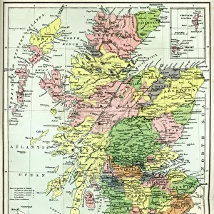
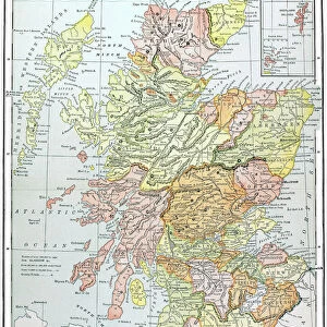
Map of Scotland in the 1520s, showing territories of the Highland Clans.
Printed color lithograph of a 19th century illustration
North Wind Picture Archives brings history to life with stock images and hand-colored illustrations
Media ID 5879160
© North Wind Picture Archives
1500s 16th Century British Europe Great Britain Medieval Scot Scot Land Scottish Territory Clan Highlander Scotch
20"x16" (+3" Border) Fine Art Print
Step back in time with our exquisite Fine Art Print from Media Storehouse, featuring the captivating map GGBR2A-00076 from North Wind Picture Archives. This stunning 19th century illustration transports you to Scotland in the 1520s, showcasing the territories of the Highland Clans in rich, vibrant color. Perfect for adding historical charm to any room, this printed lithograph is a must-have for history enthusiasts and art collectors alike. Bring the past to life with this beautiful and intricately detailed piece.
20x16 image printed on 26x22 Fine Art Rag Paper with 3" (76mm) white border. Our Fine Art Prints are printed on 300gsm 100% acid free, PH neutral paper with archival properties. This printing method is used by museums and art collections to exhibit photographs and art reproductions.
Our fine art prints are high-quality prints made using a paper called Photo Rag. This 100% cotton rag fibre paper is known for its exceptional image sharpness, rich colors, and high level of detail, making it a popular choice for professional photographers and artists. Photo rag paper is our clear recommendation for a fine art paper print. If you can afford to spend more on a higher quality paper, then Photo Rag is our clear recommendation for a fine art paper print.
Estimated Image Size (if not cropped) is 37.5cm x 50.8cm (14.8" x 20")
Estimated Product Size is 55.9cm x 66cm (22" x 26")
These are individually made so all sizes are approximate
Artwork printed orientated as per the preview above, with portrait (vertical) orientation to match the source image.
FEATURES IN THESE COLLECTIONS
> Arts
> Art Movements
> Medieval Art
> Europe
> France
> Canton
> Landes
> Europe
> United Kingdom
> Scotland
> Highlands
> Related Images
> Europe
> United Kingdom
> Scotland
> Maps
> Europe
> United Kingdom
> Scotland
> Posters
> Europe
> United Kingdom
> Scotland
> Related Images
> Maps and Charts
> Related Images
> North Wind Picture Archives
> British history
> North Wind Picture Archives
> Maps
EDITORS COMMENTS
This 19th-century lithograph print takes us back in time to the 1520s, offering a glimpse into the territories of the Highland Clans in Scotland. The intricate map showcases the rich history and medieval heritage of this great nation. With its vibrant printed colors, every detail comes to life, transporting us to an era when clans and their territories played a significant role in Scottish society. The illustration provides a fascinating insight into the complex web of clan affiliations and territorial boundaries that defined Scotland during this period. It serves as a visual representation of power struggles, alliances, and cultural identities that shaped the destiny of these proud highlanders. As we explore this vintage artwork, one cannot help but marvel at how it captures both historical accuracy and artistic beauty. The meticulous craftsmanship transports us through time, allowing us to appreciate not only the geography but also the artistry behind cartography during those times. This remarkable piece is more than just an illustration; it is a testament to Scottish history and European artistry. It reminds us of our shared past while igniting curiosity about what life was like for these brave Scots who called themselves highlanders. Whether you are fascinated by genealogy or simply captivated by ancient maps, this print offers an enchanting window into Scotland's past - a treasure for any history enthusiast or lover of fine art alike.
MADE IN AUSTRALIA
Safe Shipping with 30 Day Money Back Guarantee
FREE PERSONALISATION*
We are proud to offer a range of customisation features including Personalised Captions, Color Filters and Picture Zoom Tools
SECURE PAYMENTS
We happily accept a wide range of payment options so you can pay for the things you need in the way that is most convenient for you
* Options may vary by product and licensing agreement. Zoomed Pictures can be adjusted in the Cart.