Fine Art Print > Universal Images Group (UIG) > Illustrations > Illustrations 1
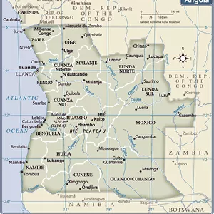
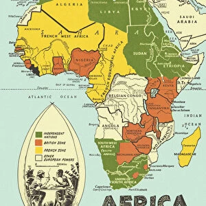
Fine Art Print : Map of Angola


![]()
Fine Art Prints from Universal Images Group (UIG)
Map of Angola
Universal Images Group (UIG) manages distribution for many leading specialist agencies worldwide
Media ID 9539759
© Dorling Kindersley/UIG
20"x16" (+3" Border) Fine Art Print
20x16 image printed on 26x22 Fine Art Rag Paper with 3" (76mm) white border. Our Fine Art Prints are printed on 300gsm 100% acid free, PH neutral paper with archival properties. This printing method is used by museums and art collections to exhibit photographs and art reproductions.
Our fine art prints are high-quality prints made using a paper called Photo Rag. This 100% cotton rag fibre paper is known for its exceptional image sharpness, rich colors, and high level of detail, making it a popular choice for professional photographers and artists. Photo rag paper is our clear recommendation for a fine art paper print. If you can afford to spend more on a higher quality paper, then Photo Rag is our clear recommendation for a fine art paper print.
Estimated Image Size (if not cropped) is 50.8cm x 36.3cm (20" x 14.3")
Estimated Product Size is 66cm x 55.9cm (26" x 22")
These are individually made so all sizes are approximate
Artwork printed orientated as per the preview above, with landscape (horizontal) orientation to match the source image.
EDITORS COMMENTS
This print showcases the intricate details of a "Map of Angola" created by renowned cartography experts, Dorling Kindersley. The vibrant colors and precise illustrations bring this African country to life, offering a visual feast for geography enthusiasts and avid travelers alike. The map effortlessly captures the diverse landscapes and geographical features that define Angola. From its vast coastal plains along the Atlantic Ocean to the lush rainforests in the north, every region is meticulously depicted with utmost accuracy. The intricate network of rivers flowing through its terrain adds an element of dynamism to this stunning illustration. As one explores this visually appealing map, it becomes evident that Angola's rich cultural heritage is deeply intertwined with its physical geography. Each province is clearly demarcated, allowing viewers to appreciate the country's administrative divisions while also gaining insights into local traditions and customs associated with each region. Whether you are planning an adventure across Angola or simply seeking knowledge about this remarkable nation, this print serves as an invaluable resource. It invites you on a virtual journey through time and space, providing a comprehensive overview of Angola's topography and landmarks. With Dorling Kindersley's expertise combined with Universal Images Group's commitment to delivering exceptional prints, this Map of Angola offers both aesthetic pleasure and educational value – making it a must-have for any geography enthusiast or lover of African culture.
MADE IN AUSTRALIA
Safe Shipping with 30 Day Money Back Guarantee
FREE PERSONALISATION*
We are proud to offer a range of customisation features including Personalised Captions, Color Filters and Picture Zoom Tools
SECURE PAYMENTS
We happily accept a wide range of payment options so you can pay for the things you need in the way that is most convenient for you
* Options may vary by product and licensing agreement. Zoomed Pictures can be adjusted in the Cart.