Fine Art Print > Universal Images Group (UIG) > Universal Images Group > Satellite and Aerial > Planet Observer 5
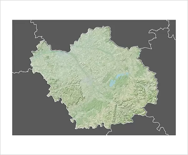
Fine Art Print : Departement of Aube, France, Relief Map


![]()
Fine Art Prints from Universal Images Group (UIG)
Departement of Aube, France, Relief Map
Relief map of the departement of Aube, France. The area is well adapted to wine-growing and particularly Champagne. This image was compiled from data acquired by LANDSAT 5 & 7 satellites combined with elevation data
Universal Images Group (UIG) manages distribution for many leading specialist agencies worldwide
Media ID 9633961
© Planet Observer
Champagne Ardenne Geographical Border Relief Map Aube Satellite View
20"x16" (+3" Border) Fine Art Print
Discover the beauty of the Departement of Aube, France, with our exquisite Fine Art Print from Media Storehouse. This captivating relief map, sourced from Universal Images Group (UIG), showcases the picturesque terrain of this region, renowned for its vineyards and world-famous Champagne production. Meticulously compiled from data acquired by LANDSAT 5 & 7 satellites, this print offers a unique perspective on the area's topography. Bring the charm of Aube into your home or office with this stunning, high-quality Fine Art Print.
20x16 image printed on 26x22 Fine Art Rag Paper with 3" (76mm) white border. Our Fine Art Prints are printed on 300gsm 100% acid free, PH neutral paper with archival properties. This printing method is used by museums and art collections to exhibit photographs and art reproductions.
Our fine art prints are high-quality prints made using a paper called Photo Rag. This 100% cotton rag fibre paper is known for its exceptional image sharpness, rich colors, and high level of detail, making it a popular choice for professional photographers and artists. Photo rag paper is our clear recommendation for a fine art paper print. If you can afford to spend more on a higher quality paper, then Photo Rag is our clear recommendation for a fine art paper print.
Estimated Image Size (if not cropped) is 50.8cm x 36cm (20" x 14.2")
Estimated Product Size is 66cm x 55.9cm (26" x 22")
These are individually made so all sizes are approximate
Artwork printed orientated as per the preview above, with landscape (horizontal) orientation to match the source image.
EDITORS COMMENTS
This print showcases the stunning relief map of the Departement of Aube in France. The intricate details and vibrant colors bring to life the geographical features of this region, renowned for its wine-growing capabilities, especially in producing Champagne. Compiled from data acquired by LANDSAT 5 & 7 satellites combined with elevation data, this image provides a unique perspective on the topography and physical geography of Aube. The horizontal composition allows viewers to immerse themselves in the beauty of this European landscape. With no people present, one can fully appreciate the natural wonders that unfold before their eyes. The geographical borders are clearly defined, highlighting Aube's distinct boundaries within Champagne-Ardenne. Cartography enthusiasts will be captivated by this color image as it offers an opportunity to explore and study the terrain in great detail. From rolling hills to valleys and rivers, every contour is meticulously depicted on this relief map. Whether you have a passion for photography or an interest in physical geography, this print from Universal Images Group (UIG) is sure to fascinate and inspire exploration
MADE IN AUSTRALIA
Safe Shipping with 30 Day Money Back Guarantee
FREE PERSONALISATION*
We are proud to offer a range of customisation features including Personalised Captions, Color Filters and Picture Zoom Tools
SECURE PAYMENTS
We happily accept a wide range of payment options so you can pay for the things you need in the way that is most convenient for you
* Options may vary by product and licensing agreement. Zoomed Pictures can be adjusted in the Cart.