Fine Art Print > Europe > France > Canton > Bas Rhin
Fine Art Print : Kazakhstan, Satellite Image


![]()
Fine Art Prints from Universal Images Group (UIG)
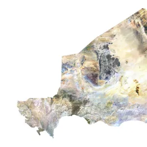
Kazakhstan, Satellite Image
Satellite view of Kazakhstan in Central Asia with country borders. This image was compiled from data acquired by LANDSAT satellite
Universal Images Group (UIG) manages distribution for many leading specialist agencies worldwide
Media ID 9634395
© Planet Observer
Alsace Bas Rhin Geographical Border Relief Map Satellite View
20"x16" (+3" Border) Fine Art Print
Discover the breathtaking beauty of Kazakhstan with our Fine Art Print from Media Storehouse. This exquisite piece showcases a satellite image of Central Asia's largest country, captured by Universal Images Group (UIG) from LANDSAT data. Witness the intricate patterns of Kazakhstan's borders against the rich tapestry of its diverse terrain. Bring the wonders of the world into your home or office with this captivating and unique Fine Art Print.
20x16 image printed on 26x22 Fine Art Rag Paper with 3" (76mm) white border. Our Fine Art Prints are printed on 300gsm 100% acid free, PH neutral paper with archival properties. This printing method is used by museums and art collections to exhibit photographs and art reproductions.
Our fine art prints are high-quality prints made using a paper called Photo Rag. This 100% cotton rag fibre paper is known for its exceptional image sharpness, rich colors, and high level of detail, making it a popular choice for professional photographers and artists. Photo rag paper is our clear recommendation for a fine art paper print. If you can afford to spend more on a higher quality paper, then Photo Rag is our clear recommendation for a fine art paper print.
Estimated Image Size (if not cropped) is 35.9cm x 50.8cm (14.1" x 20")
Estimated Product Size is 55.9cm x 66cm (22" x 26")
These are individually made so all sizes are approximate
Artwork printed orientated as per the preview above, with portrait (vertical) orientation to match the source image.
FEATURES IN THESE COLLECTIONS
> Asia
> Kazakhstan
> Maps
> Asia
> Kazakhstan
> Related Images
> Europe
> France
> Canton
> Bas Rhin
> Europe
> France
> Canton
> Rhin
> Maps and Charts
> Kazakhstan
> Maps and Charts
> Related Images
> Universal Images Group (UIG)
> Universal Images Group
> Satellite and Aerial
> Planet Observer 6
EDITORS COMMENTS
This stunning print showcases the breathtaking beauty of Kazakhstan, a country nestled in Central Asia. Captured from space by the LANDSAT satellite, this satellite image offers a unique perspective on the vast landscapes and intricate topography that define this remarkable nation. With its borders clearly outlined, viewers can appreciate the geographical expanse of Kazakhstan as it stretches across the frame. The vibrant colors and detailed relief map provide an immersive experience, allowing us to explore every nook and cranny of this diverse region. From towering mountain ranges to expansive plains, Kazakhstan's physical geography is beautifully displayed in this vertical composition. As we gaze upon this photograph, we are reminded of the immense power and capabilities of modern technology in capturing our world from above. The absence of human presence emphasizes nature's grandeur and invites us to reflect on our place within it. Whether you are a cartography enthusiast or simply captivated by Earth's natural wonders, this print is sure to ignite your sense of adventure. It serves as a testament to both the artistic value and scientific significance that such images hold
MADE IN AUSTRALIA
Safe Shipping with 30 Day Money Back Guarantee
FREE PERSONALISATION*
We are proud to offer a range of customisation features including Personalised Captions, Color Filters and Picture Zoom Tools
SECURE PAYMENTS
We happily accept a wide range of payment options so you can pay for the things you need in the way that is most convenient for you
* Options may vary by product and licensing agreement. Zoomed Pictures can be adjusted in the Cart.