Home > Arts > Still life artwork > Watercolor paintings > Fine art
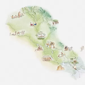
Illustrated map of ancient Babylon

![]()
Wall Art and Photo Gifts from Fine Art Storehouse
Illustrated map of ancient Babylon
Unleash your creativity and transform your space into a visual masterpiece!
Dorling Kindersley
Media ID 13540779
© This content is subject to copyright
Ancient Civilisations Ancient History Arabian Peninsula Army Babil Babylon Background People Empire Geography Illustrated Map Incidental People Large Group Of People Watercolour Painting
FEATURES IN THESE COLLECTIONS
> Arts
> Still life artwork
> Watercolor paintings
> Fine art
> Fine Art Storehouse
> Photo Libraries
> Dorling Kindersley Prints
> Maps and Charts
> Early Maps
EDITORS COMMENTS
This print showcases an intricately illustrated map of ancient Babylon, transporting us back in time to one of the most significant civilizations in history. Created by Dorling Kindersley, this watercolor painting beautifully captures the essence and grandeur of this ancient city. The map is a testament to the rich heritage and cultural significance of Babylon, with its detailed depiction of physical geography and architectural marvels. The Arabian Peninsula serves as a backdrop, adding depth to the scene while emphasizing Babylon's strategic location. Intriguingly, amidst the sprawling empire portrayed on this horizontal canvas, we can observe a large group of people engaged in various activities. This inclusion adds life and context to the illustration, allowing us to imagine what daily life might have been like during that era. The artist's skillful use of color brings vibrancy to every corner of this studio shot. Against a clean white background, each stroke reveals meticulous attention to detail - from the bustling army formations to incidental individuals going about their day. As we gaze upon this remarkable piece, it serves as a reminder that behind every ancient civilization lies stories waiting to be discovered. With its historical significance and artistic brilliance combined into one frame, this illustrated map offers both educational value and aesthetic pleasure for any admirer of ancient history or fine art enthusiasts alike.
MADE IN AUSTRALIA
Safe Shipping with 30 Day Money Back Guarantee
FREE PERSONALISATION*
We are proud to offer a range of customisation features including Personalised Captions, Color Filters and Picture Zoom Tools
SECURE PAYMENTS
We happily accept a wide range of payment options so you can pay for the things you need in the way that is most convenient for you
* Options may vary by product and licensing agreement. Zoomed Pictures can be adjusted in the Cart.