Home > Arts > Still life artwork > Watercolor paintings > Fine art
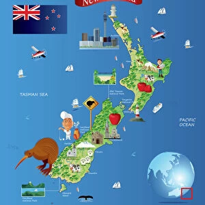
Illustrated map of New Zealand, Hawaiian Islands, Polynesian Islands and native population

![]()
Wall Art and Photo Gifts from Fine Art Storehouse
Illustrated map of New Zealand, Hawaiian Islands, Polynesian Islands and native population
Unleash your creativity and transform your space into a visual masterpiece!
Dorling Kindersley
Media ID 13540761
© This content is subject to copyright
Easter Island Geography Hawaii Hawaii Islands Illustrated Map Indigenous Culture Island Large Group Of People Maori New Zealand Pacific Islands Pacific Ocean Polynesia Polynesian Rapa Nui Sailboat Sailing Boat Watercolour Painting
FEATURES IN THESE COLLECTIONS
> Arts
> Still life artwork
> Watercolor paintings
> Fine art
> Fine Art Storehouse
> Photo Libraries
> Dorling Kindersley Prints
> Oceania
> New Zealand
> Maps
EDITORS COMMENTS
This print titled "Illustrated map of New Zealand, Hawaiian Islands, Polynesian Islands and native population" takes us on a visual journey through the rich cultural tapestry of the Pacific. Created by Dorling Kindersley, this watercolor painting showcases the beauty and diversity of these enchanting islands. The vibrant colors and intricate details bring to life the stunning landscapes and indigenous cultures that inhabit these lands. From the majestic Maori people in New Zealand to the ancient Rapa Nui civilization in Easter Island, every corner of this map is filled with fascinating stories waiting to be discovered. A sailboat gracefully glides across the Pacific Ocean, symbolizing both exploration and connection between these distant islands. The presence of statues scattered throughout signifies their significance as cultural landmarks that have stood for centuries. Against a crisp white background, each element stands out boldly, allowing us to appreciate every brushstroke and delicate line. This studio shot captures not only an artistic masterpiece but also serves as a valuable educational tool for those interested in geography or indigenous cultures. As we gaze upon this illustrated map, we are reminded of our shared humanity and interconnectedness across vast oceans. It invites us to embark on our own voyage of discovery while honoring the heritage and traditions that have shaped these remarkable places.
MADE IN AUSTRALIA
Safe Shipping with 30 Day Money Back Guarantee
FREE PERSONALISATION*
We are proud to offer a range of customisation features including Personalised Captions, Color Filters and Picture Zoom Tools
SECURE PAYMENTS
We happily accept a wide range of payment options so you can pay for the things you need in the way that is most convenient for you
* Options may vary by product and licensing agreement. Zoomed Pictures can be adjusted in the Cart.