Home > Maps and Charts > World
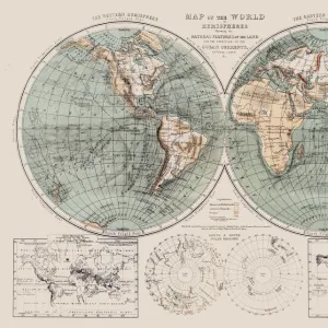
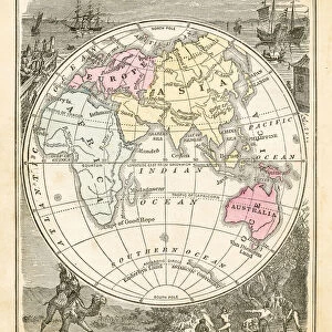
Eastern Hemisphere map 1856

![]()
Wall Art and Photo Gifts from Fine Art Storehouse
Eastern Hemisphere map 1856
Mitchells Modern Atlas - Published by E.H. Buttler & Co - Philadelphia 1867
Unleash your creativity and transform your space into a visual masterpiece!
THEPALMER
Media ID 13668941
© Roberto A Sanchez
62990 Cartographer Earth East East Asia Globe Man Made Object Globe Navigational Equipment Hemisphere Planet Earth Space Topography World Map Drawing Art Product
FEATURES IN THESE COLLECTIONS
> Asia
> Related Images
> Fine Art Storehouse
> The Magical World of Illustration
> Palmer Illustrated Collection
> Fine Art Storehouse
> Map
> Historical Maps
> Maps and Charts
> Early Maps
> Maps and Charts
> World
EDITORS COMMENTS
This print showcases a remarkable piece of cartographic history - an Eastern Hemisphere map from 1856, originally published in the renowned Mitchell's Modern Atlas. Created by the skilled hands of cartographers at E. H. Buttler & Co in Philadelphia, this antique illustration offers a fascinating glimpse into the world as it was perceived over a century ago. The intricate details and topographical engravings on this map highlight not only the physical geography but also the vastness and diversity of our planet Earth. From East Asia to distant lands yet to be explored, every corner is meticulously depicted with precision and artistry. As we gaze upon this vertical masterpiece, we are reminded of how mankind has always sought to navigate and understand our world. The globe, a man-made object that aids us in comprehending our place within space, serves as a symbol of human curiosity and exploration. The craftsmanship evident in this drawing art product transports us back to an era when maps were cherished possessions that unlocked knowledge about far-off lands. It invites us to appreciate both the scientific accuracy and artistic beauty inherent in cartography. With its rich historical significance and timeless allure, "Eastern Hemisphere Map 1856" by THEPALMER is more than just an image; it is a tangible connection between past and present – reminding us that while technology may have evolved since then, our fascination with mapping out our world remains unchanged.
MADE IN AUSTRALIA
Safe Shipping with 30 Day Money Back Guarantee
FREE PERSONALISATION*
We are proud to offer a range of customisation features including Personalised Captions, Color Filters and Picture Zoom Tools
SECURE PAYMENTS
We happily accept a wide range of payment options so you can pay for the things you need in the way that is most convenient for you
* Options may vary by product and licensing agreement. Zoomed Pictures can be adjusted in the Cart.