Home > Arts > Landscape paintings > Forest and woodland scenes > Forest artwork
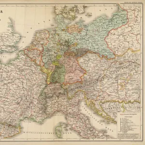
Geological map of Thuringia, Germany, lithograph, published in 1897

![]()
Wall Art and Photo Gifts from Fine Art Storehouse
Geological map of Thuringia, Germany, lithograph, published in 1897
Geological map of Thuringia, Germany. Lithograph, published in 1897
Unleash your creativity and transform your space into a visual masterpiece!
ZU_09
Media ID 35843072
Aging Process Basalt Bavaria Brown Carboniferous Cretaceous Devonian Franconia Geology Jurassic Land Rock Object Slate Rock Thuringia Triassic Diorite Multi Colored Shale Silurian Tertiary Period Thuringian Forest
FEATURES IN THESE COLLECTIONS
> Arts
> Landscape paintings
> Forest and woodland scenes
> Forest artwork
> Fine Art Storehouse
> Map
> Historical Maps
> Maps and Charts
> Early Maps
> Maps and Charts
> Geological Map
EDITORS COMMENTS
1. Title: Geological Map of Thuringia, Germany (1897) This intricately detailed lithograph, published in 1897, showcases the geological makeup of Thuringia, a region in central Germany. The map, a testament to the scientific advancements of the 19th century, is a vibrant representation of the various geological formations that underlie the Thuringian landscape. The map is divided into distinct areas, each marked by unique geological features. The Thuringian Forest, a densely wooded mountain range, is depicted in the northern part of the map, while the southern regions are dominated by the Franconian and Bavarian territories. The map's multi-colored design highlights the diverse geological history of the region, with different time periods marked by distinct hues. The map's aging process adds to its charm, as the creases and discoloration serve as reminders of its rich history. The Tertiary, Cretaceous, Jurassic, Triassic, Devonian, and Silurian periods are all represented, with various rock formations labeled in English and German. The geological formations depicted on the map include a range of rock types, such as slate, shale, granite, basalt, porphyry, diorite, and gabbro. The map's horizontal orientation and meticulous engraving technique provide a clear and comprehensive view of the underlying geological structures. The map's intricate details offer a glimpse into the past, revealing the complex history of the land beneath our feet. The various rock formations, each with their unique characteristics, tell a story of the Earth's evolution over millions of years. This lithograph is not just a map, but a window into the geological history of Thuringia and Europe as a whole.
MADE IN AUSTRALIA
Safe Shipping with 30 Day Money Back Guarantee
FREE PERSONALISATION*
We are proud to offer a range of customisation features including Personalised Captions, Color Filters and Picture Zoom Tools
SECURE PAYMENTS
We happily accept a wide range of payment options so you can pay for the things you need in the way that is most convenient for you
* Options may vary by product and licensing agreement. Zoomed Pictures can be adjusted in the Cart.