Home > Arts > Contemporary art > Digital artwork > Street art
CT Middlesex Deep River Vector Road Map

![]()
Wall Art and Photo Gifts from Fine Art Storehouse
CT Middlesex Deep River Vector Road Map
CT Middlesex Deep River Vector Road Map. All source data is in the public domain. U.S. Census Bureau Census Tiger. Used Layers: areawater, linearwater, roads, rails, cousub, pointlm, uac10
Unleash your creativity and transform your space into a visual masterpiece!
Frank Ramspott
Media ID 20687635
© Frank Ramspott, all rights reserved
City Map Computer Graphic Connecticut Connecticut River County Digital Composite District Essex Geographical Border Middlesex Road Map Text Vector Village Brockway Chester Digitally Generated Image Lake View Orchard Hill Winthrop
FEATURES IN THESE COLLECTIONS
> Animals
> Mammals
> Cats (Wild)
> Tiger
> Animals
> Mammals
> Muridae
> Water Mouse
> Arts
> Contemporary art
> Digital artwork
> Street art
> Arts
> Landscape paintings
> Waterfall and river artworks
> River artworks
> Arts
> Portraits
> Pop art gallery
> Street art portraits
> Arts
> Street art graffiti
> Digital art
> Digital paintings
> Europe
> United Kingdom
> England
> Essex
> Related Images
> Europe
> United Kingdom
> England
> Middlesex
> Related Images
> Fine Art Storehouse
> Map
> Reference Maps
> Maps and Charts
> Related Images
> Popular Themes
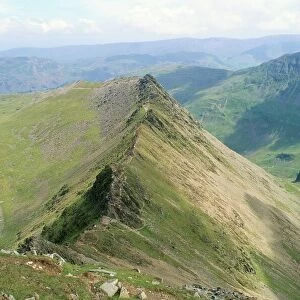
> Lake District
EDITORS COMMENTS
This print showcases the intricate details of the CT Middlesex Deep River Vector Road Map. Created by talented cartographer Frank Ramspott, this digitally generated image is a true masterpiece in design and precision. With no people present, the focus lies solely on the vibrant colors and expertly crafted vector elements that bring this map to life. The map encompasses various layers of information sourced from public domain data, including areas of water, roads, railways, counties, points of interest, and more. It beautifully captures the physical geography of Connecticut's Middlesex County with its rivers, lakes, villages, towns, and cities like Deep River and Chester. Every street name and geographical border is meticulously labeled with clear text for easy navigation. The inclusion of important landmarks such as Lake View and Orchard Hill adds depth to this comprehensive road map. As a digital composite artwork created using computer graphics techniques, this print seamlessly blends together different elements to create a visually stunning representation of Connecticut's landscape. Its versatility makes it an ideal addition to any space - be it an office or home - where appreciation for art meets practicality in finding one's way around
MADE IN AUSTRALIA
Safe Shipping with 30 Day Money Back Guarantee
FREE PERSONALISATION*
We are proud to offer a range of customisation features including Personalised Captions, Color Filters and Picture Zoom Tools
SECURE PAYMENTS
We happily accept a wide range of payment options so you can pay for the things you need in the way that is most convenient for you
* Options may vary by product and licensing agreement. Zoomed Pictures can be adjusted in the Cart.