Home > Animals > Birds > Gruiformes > Rallidae > Water Rail
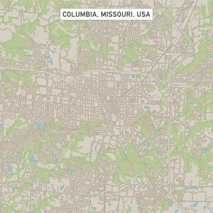
MA Middlesex Acton Vector Road Map

![]()
Wall Art and Photo Gifts from Fine Art Storehouse
MA Middlesex Acton Vector Road Map
MA Middlesex Acton Vector Road Map. All source data is in the public domain. U.S. Census Bureau Census Tiger. Used Layers: areawater, linearwater, roads, rails, cousub, pointlm, uac10
Unleash your creativity and transform your space into a visual masterpiece!
Frank Ramspott
Media ID 20691561
© Frank Ramspott, all rights reserved
City Map Computer Graphic County Digital Composite District Geographical Border Massachusetts Middlesex Road Map Text Vector Acton Digitally Generated Image Maynard
FEATURES IN THESE COLLECTIONS
> Animals
> Birds
> Gruiformes
> Rallidae
> Water Rail
> Animals
> Mammals
> Cats (Wild)
> Tiger
> Arts
> Landscape paintings
> Waterfall and river artworks
> River artworks
> Arts
> Portraits
> Pop art gallery
> Street art portraits
> Arts
> Street art graffiti
> Digital art
> Digital paintings
> Europe
> United Kingdom
> England
> Middlesex
> Related Images
> Fine Art Storehouse
> Map
> Reference Maps
> Maps and Charts
> Related Images
EDITORS COMMENTS
This print showcases the MA Middlesex Acton Vector Road Map, a stunning piece of cartography art. Created by Frank Ramspott, this digitally generated image is a testament to his exceptional design skills and attention to detail. The map encompasses various layers including areawater, linearwater, roads, rails, cousub, pointlm, and uac10. All source data used in its creation is in the public domain and sourced from the U. S. Census Bureau Census Tiger. With no people present in the image, it allows viewers to focus solely on the intricate details of this colorful vector map. The physical geography of Middlesex County comes alive as city borders are clearly defined along with streets and rivers that wind through Acton's picturesque landscapes. Notable locations such as Damons Mills Westvale, Maynard, Nagog Hill, and Village of Nagog Woods are highlighted on this comprehensive road map. Each element seamlessly blends together to create a visually appealing computer graphic that would be an excellent addition to any space. Whether you have a passion for maps or simply appreciate fine artistry, this print offers both aesthetic appeal and practicality. It serves as a reminder of our ever-changing world while showcasing the beauty found within Massachusetts' Middlesex County.
MADE IN AUSTRALIA
Safe Shipping with 30 Day Money Back Guarantee
FREE PERSONALISATION*
We are proud to offer a range of customisation features including Personalised Captions, Color Filters and Picture Zoom Tools
SECURE PAYMENTS
We happily accept a wide range of payment options so you can pay for the things you need in the way that is most convenient for you
* Options may vary by product and licensing agreement. Zoomed Pictures can be adjusted in the Cart.