Home > Animals > Birds > Gruiformes > Rallidae > Water Rail
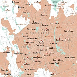
MA Worcester Phillipston Vector Road Map

![]()
Wall Art and Photo Gifts from Fine Art Storehouse
MA Worcester Phillipston Vector Road Map
MA Worcester Phillipston Vector Road Map. All source data is in the public domain. U.S. Census Bureau Census Tiger. Used Layers: areawater, linearwater, roads, rails, cousub, pointlm, uac10
Unleash your creativity and transform your space into a visual masterpiece!
Frank Ramspott
Media ID 20691725
© Frank Ramspott, all rights reserved
City Map Computer Graphic County Digital Composite District Geographical Border Massachusetts Road Map Text Vector Worcester Digitally Generated Image Prospect Hill Templeton
FEATURES IN THESE COLLECTIONS
> Animals
> Birds
> Gruiformes
> Rallidae
> Water Rail
> Animals
> Mammals
> Cats (Wild)
> Tiger
> Arts
> Landscape paintings
> Waterfall and river artworks
> River artworks
> Arts
> Portraits
> Pop art gallery
> Street art portraits
> Arts
> Street art graffiti
> Digital art
> Digital paintings
> Fine Art Storehouse
> Map
> Reference Maps
> Maps and Charts
> Related Images
> North America
> United States of America
> Massachusetts
> Worcester
EDITORS COMMENTS
This print titled "MA Worcester Phillipston Vector Road Map" showcases a meticulously designed and digitally generated image of the Massachusetts region. Created by Frank Ramspott, this artwork beautifully combines elements of cartography and modern design to present an accurate representation of the area. The map incorporates various layers sourced from the public domain, including data from the U. S. Census Bureau Census Tiger. With attention to detail, it features essential geographical components such as rivers, lakes, roads, rails, cities, and districts. The vibrant colors used in this vector image bring life to the physical geography depicted. While devoid of human presence in its composition, this artwork speaks volumes about the interconnectedness of communities within Massachusetts. From Worcester to Phillipston and beyond, each city and village is intricately connected through a network of streets and highways displayed on this map. Frank Ramspott's digital composite skillfully captures both the beauty and functionality of a road map while showcasing his expertise in computer graphics. It serves as an excellent reference tool for locals or visitors exploring these areas or simply appreciating their unique characteristics
MADE IN AUSTRALIA
Safe Shipping with 30 Day Money Back Guarantee
FREE PERSONALISATION*
We are proud to offer a range of customisation features including Personalised Captions, Color Filters and Picture Zoom Tools
SECURE PAYMENTS
We happily accept a wide range of payment options so you can pay for the things you need in the way that is most convenient for you
* Options may vary by product and licensing agreement. Zoomed Pictures can be adjusted in the Cart.