Home > North America > United States of America > Arkansas > Little Rock
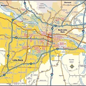
Little Rock Arkansas US City Street Map

![]()
Wall Art and Photo Gifts from Fine Art Storehouse
Little Rock Arkansas US City Street Map
Vector Illustration of a City Street Map of Little Rock, Arkansas, USA. Scale 1:60, 000.
All source data is in the public domain.
U.S. Geological Survey, US Topo
Used Layers:
USGS The National Map: National Hydrography Dataset (NHD)
USGS The National Map: National Transportation Dataset (NTD)
Unleash your creativity and transform your space into a visual masterpiece!
Frank Ramspott
Media ID 15192886
© Frank Ramspott, all rights reserved
Aerial View Arkansas City Map Computer Graphic Directly Above Downtown District Gray Road Map Text Digitally Generated Image Green Color Little Rock White Color
FEATURES IN THESE COLLECTIONS
> Aerial Photography
> Related Images
> Animals
> Insects
> Hemiptera
> Green Scale
> Arts
> Landscape paintings
> Waterfall and river artworks
> River artworks
> Arts
> Portraits
> Pop art gallery
> Street art portraits
> Fine Art Storehouse
> Map
> Street Maps
> Fine Art Storehouse
> Map
> USA Maps
> Maps and Charts
> Geological Map
> North America
> United States of America
> Arkansas
> Little Rock
> North America
> United States of America
> Lakes
> Related Images
> North America
> United States of America
> Maps
EDITORS COMMENTS
This print showcases a meticulously detailed city street map of Little Rock, Arkansas, USA. With a scale of 1:60,000, every intricate feature is beautifully illustrated in this vector image. The source data used for this artwork is in the public domain and comes from the U. S. Geological Survey's National Hydrography Dataset (NHD) and National Transportation Dataset (NTD), both provided by USGS The National Map. The vibrant colors of gray, blue, white, and green bring life to this digitally generated image. From the downtown district to the serene lake and river that grace its surroundings, every element is accurately represented on this map. This visually stunning piece captures the essence of Little Rock's streets and roads with utmost precision. Designed by Frank Ramspott exclusively for Fine Art Storehouse, this print offers an aerial view directly above the cityscape. It portrays not only physical geography but also serves as a testament to exceptional cartography skills. With no people present in the image itself, all attention is drawn towards exploring each road and corner within Little Rock's urban landscape. Whether you are a resident or simply fascinated by maps and design, this print will surely captivate your imagination with its remarkable level of detail and artistry.
MADE IN AUSTRALIA
Safe Shipping with 30 Day Money Back Guarantee
FREE PERSONALISATION*
We are proud to offer a range of customisation features including Personalised Captions, Color Filters and Picture Zoom Tools
SECURE PAYMENTS
We happily accept a wide range of payment options so you can pay for the things you need in the way that is most convenient for you
* Options may vary by product and licensing agreement. Zoomed Pictures can be adjusted in the Cart.