Home > Animals > Insects > Hemiptera > Green Scale
Rancho Cucamonga California US City Street Map

![]()
Wall Art and Photo Gifts from Fine Art Storehouse
Rancho Cucamonga California US City Street Map
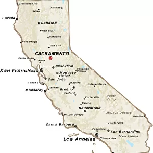
Vector Illustration of a City Street Map of Rancho Cucamonga, California, USA. Scale 1:60, 000.
All source data is in the public domain.
U.S. Geological Survey, US Topo
Used Layers:
USGS The National Map: National Hydrography Dataset (NHD)
USGS The National Map: National Transportation Dataset (NTD)
Unleash your creativity and transform your space into a visual masterpiece!
Frank Ramspott
Media ID 15055121
© Frank Ramspott, all rights reserved
Aerial View California City Map Computer Graphic Directly Above Downtown District Gray Road Map Text Digitally Generated Image Green Color White Color
FEATURES IN THESE COLLECTIONS
> Aerial Photography
> Related Images
> Animals
> Insects
> Hemiptera
> Green Scale
> Arts
> Landscape paintings
> Waterfall and river artworks
> River artworks
> Arts
> Portraits
> Pop art gallery
> Street art portraits
> Fine Art Storehouse
> Map
> Street Maps
> Fine Art Storehouse
> Map
> USA Maps
> Maps and Charts
> Geological Map
> North America
> United States of America
> California
> Related Images
> North America
> United States of America
> Lakes
> Related Images
> North America
> United States of America
> Maps
EDITORS COMMENTS
This print showcases a meticulously detailed city street map of Rancho Cucamonga, California, USA. The vector illustration presents an aerial view of the downtown district, highlighting the intricate network of roads and streets that make up this vibrant city. With a scale of 1:60,000, every corner and intersection is accurately depicted to provide an immersive cartographic experience. The design seamlessly combines various layers from reliable sources such as the U. S. Geological Survey's National Hydrography Dataset (NHD) and National Transportation Dataset (NTD). These layers contribute to the comprehensive portrayal of essential features like rivers, lakes, and transportation routes within Rancho Cucamonga. Digitally generated with precision and creativity by Frank Ramspott, this visually striking image captures the essence of this Californian town's physical geography. The color palette includes shades of gray for roads and streets while green represents lush areas such as parks or gardens. Blue signifies water bodies like rivers or lakes while white adds clarity to text labels on the map. With no people in sight, viewers can fully immerse themselves in exploring every inch of this beautifully crafted city map. Whether you are a resident seeking familiarity or a visitor planning your next adventure in Rancho Cucamonga, this artwork serves as both an aesthetically pleasing piece and a practical reference tool for navigation purposes.
MADE IN AUSTRALIA
Safe Shipping with 30 Day Money Back Guarantee
FREE PERSONALISATION*
We are proud to offer a range of customisation features including Personalised Captions, Color Filters and Picture Zoom Tools
SECURE PAYMENTS
We happily accept a wide range of payment options so you can pay for the things you need in the way that is most convenient for you
* Options may vary by product and licensing agreement. Zoomed Pictures can be adjusted in the Cart.