Home > North America > United States of America > Utah > Salt Lake City
Salt Lake City Utah US City Street Map

![]()
Wall Art and Photo Gifts from Fine Art Storehouse
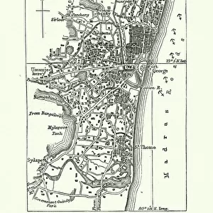
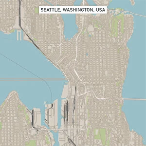
Salt Lake City Utah US City Street Map
Vector Illustration of a City Street Map of Salt Lake City, Utah, USA. Scale 1:60, 000.
All source data is in the public domain.
U.S. Geological Survey, US Topo
Used Layers:
USGS The National Map: National Hydrography Dataset (NHD)
USGS The National Map: National Transportation Dataset (NTD)
Unleash your creativity and transform your space into a visual masterpiece!
Frank Ramspott
Media ID 15054969
© Frank Ramspott, all rights reserved
Aerial View City Map Computer Graphic Directly Above Downtown District Gray Road Map Text Utah Digitally Generated Image Green Color Salt Lake City White Color
FEATURES IN THESE COLLECTIONS
> Aerial Photography
> Related Images
> Animals
> Insects
> Hemiptera
> Green Scale
> Arts
> Landscape paintings
> Waterfall and river artworks
> River artworks
> Arts
> Portraits
> Pop art gallery
> Street art portraits
> Fine Art Storehouse
> Map
> Street Maps
> Fine Art Storehouse
> Map
> USA Maps
> Maps and Charts
> Geological Map
> North America
> United States of America
> Lakes
> Related Images
> North America
> United States of America
> Maps
> North America
> United States of America
> Utah
> Salt Lake City
EDITORS COMMENTS
This print showcases a detailed and meticulously crafted city street map of Salt Lake City, Utah, USA. With a scale of 1:60,000, every intricate detail is brought to life in this vector illustration. The artist has skillfully utilized various layers from the USGS The National Map to create this stunning piece. The city's downtown district can be seen prominently along with its surrounding areas including the mesmerizing lake and river. Roads crisscross throughout the map, highlighting the extensive network that connects this vibrant city. This visually appealing design is digitally generated and features an aerial view directly above Salt Lake City. In shades of gray, blue, white, and green color palettes are used to depict different elements on the map such as water bodies and vegetation. The inclusion of text adds further context while maintaining a clean aesthetic. Frank Ramspott's artistic vision shines through in this remarkable artwork which seamlessly blends cartography with computer graphics. It is worth noting that all source data used for creating this masterpiece is in the public domain courtesy of U. S Geological Survey (USGS) - specifically their National Hydrography Dataset (NHD) and National Transportation Dataset (NTD). This print offers a unique perspective on Salt Lake City's physical geography without any human presence captured within it. A must-have for those who appreciate fine art combined with accurate mapping techniques!
MADE IN AUSTRALIA
Safe Shipping with 30 Day Money Back Guarantee
FREE PERSONALISATION*
We are proud to offer a range of customisation features including Personalised Captions, Color Filters and Picture Zoom Tools
SECURE PAYMENTS
We happily accept a wide range of payment options so you can pay for the things you need in the way that is most convenient for you
* Options may vary by product and licensing agreement. Zoomed Pictures can be adjusted in the Cart.