Home > Europe > Montenegro > Maps
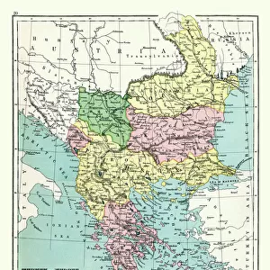
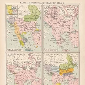
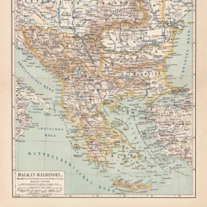
Map of Romania, Serbia, Montenegro, and Bulgaria 19th Century

![]()
Wall Art and Photo Gifts from Fine Art Storehouse
Map of Romania, Serbia, Montenegro, and Bulgaria 19th Century
Vintage engraving of a Map of Romania, Serbia, Montenegro, and Bulgaria 19th Century, European Turkey
Unleash your creativity and transform your space into a visual masterpiece!
duncan1890
Media ID 19684335
© of Duncan P Walker
FEATURES IN THESE COLLECTIONS
> Asia
> Turkey
> Related Images
> Europe
> Montenegro
> Maps
> Fine Art Storehouse
> Map
> Historical Maps
> Maps and Charts
> Early Maps
> Maps and Charts
> Montenegro
EDITORS COMMENTS
This vintage engraving takes us back to the 19th century, offering a glimpse into the intricate details of a map showcasing Romania, Serbia, Montenegro, and Bulgaria. The print showcases the rich historical tapestry of this region known as European Turkey during that era. The map's delicate engravings bring to life the borders and topography of these countries with remarkable precision. Each line tells a story of political boundaries, cultural exchange, and geographical diversity. As we explore closer, we can appreciate the meticulous craftsmanship that went into creating this piece. Romania emerges as an enchanting land adorned with lush forests and winding rivers while Serbia stands proudly amidst its rolling hills and fertile plains. Montenegro captivates our attention with its rugged mountains cascading down towards picturesque coastlines along the Adriatic Sea. Finally, Bulgaria reveals itself as a vibrant mosaic of landscapes ranging from vast plains to majestic mountain ranges. As we immerse ourselves in this vintage masterpiece by duncan1890 from Fine Art Storehouse, it is impossible not to feel transported back in time - witnessing an era when cartography was both artistry and science combined. This print serves as a reminder of how maps have always been more than just navigational tools; they are windows into history itself – revealing stories waiting to be discovered by those who dare to look closely enough.
MADE IN AUSTRALIA
Safe Shipping with 30 Day Money Back Guarantee
FREE PERSONALISATION*
We are proud to offer a range of customisation features including Personalised Captions, Color Filters and Picture Zoom Tools
SECURE PAYMENTS
We happily accept a wide range of payment options so you can pay for the things you need in the way that is most convenient for you
* Options may vary by product and licensing agreement. Zoomed Pictures can be adjusted in the Cart.