Home > Asia > Israel > Lakes > Sea of Galilee
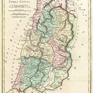
Antique map of the holy land of Sinai peninsula

![]()
Wall Art and Photo Gifts from Fine Art Storehouse
Antique map of the holy land of Sinai peninsula
Unleash your creativity and transform your space into a visual masterpiece!
Hemera Technologies
Media ID 13609413
© Getty Images
Area Border Cross Direction Document Geographical Locations Geography Holding Holy Land Inset Israel Jerusalem Lake Tiberius Land Legend Location Mediterranean Mediterranean Culture Middle East One Person Only One Woman Only Palestine Palestinian Persian Gulf Pictures Place Positioning Red Sea Scale Scene Scenes Scroll Sea Of Galilee Sinai Egypt Sinai Peninsula Territory Text Woman Words Gulf Of Suez
FEATURES IN THESE COLLECTIONS
> Africa
> Egypt
> Lakes
> Related Images
> Asia
> Israel
> Jerusalem Heritage Sites
> Old City of Jerusalem and its Walls
> Asia
> Israel
> Lakes
> Sea of Galilee
> Asia
> Palestine
> Jerusalem
> Fine Art Storehouse
> Map
> Historical Maps
> Maps and Charts
> Early Maps
EDITORS COMMENTS
This print showcases an exquisite antique map of the holy land, specifically the Sinai Peninsula. With its rich historical significance and intricate details, this archival piece transports viewers to a bygone era. The woman in the photograph is seen holding the map delicately, highlighting its importance as a document of cartography and geography. The map features various elements that add depth to its storytelling. From borders and legends to insets and scales, every aspect has been meticulously engraved to provide accurate information about this sacred territory. Jerusalem, Palestine, Israel, and other geographical locations are clearly marked alongside bodies of water like the Mediterranean Sea, Red Sea, Persian Gulf, and even Lake Tiberius (Sea of Galilee). As we admire this vintage artwork outdoors against a picturesque backdrop, it reminds us of the Middle East's profound history. The scenes depicted on the map offer glimpses into ancient civilizations that once thrived in these lands. With Hemera Technologies' expertise in photography and Fine Art Storehouse's commitment to preserving cultural heritage through art prints like these ones—this remarkable image captures our attention with its vibrant colors and vertical composition. It serves as a testament to human curiosity about our world's past while celebrating both physical geography and capital cities within one frame.
MADE IN AUSTRALIA
Safe Shipping with 30 Day Money Back Guarantee
FREE PERSONALISATION*
We are proud to offer a range of customisation features including Personalised Captions, Color Filters and Picture Zoom Tools
SECURE PAYMENTS
We happily accept a wide range of payment options so you can pay for the things you need in the way that is most convenient for you
* Options may vary by product and licensing agreement. Zoomed Pictures can be adjusted in the Cart.